 Boyd County 1895 (Image is a link to a larger version) |
Be sure to check the list of names that Doris has found in various cemeteries, newspapers and books for Boyd and Holt Counties
Boyd Co. Cemeteries Holt Co. Cemeteries Cemeteries in bordering Counties
|
Boyd County 1895 (Image is a link to a larger version) |
| Feature Name | Feature Type | County | Map | Notes |
| Books | Footprints on the Prairie--Inman, Stafford Community History--Including South Valley --By Sarah O'Connel Michaelis |
|||
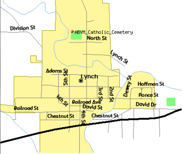
| ABVM Catholic Cemetery - NEW!! |
Cemetery | Boyd | Map | Lynch, Nebraska Cemetery is just north of North Street and fourth Street, on the west side |
| Agee, Nebraska |
Town | Boyd | Agee was 14 miles north of O'Neil | |
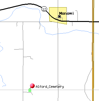
| Alford Cemetery | Cemetery | Boyd | Map | Alford Cemetery is 1 mile west, 2 miles south and ¼ mile east of Monowi. Named after William Alford. Frank Bates donated the first land for the cemetery and sold another acre to the cemetery later. |
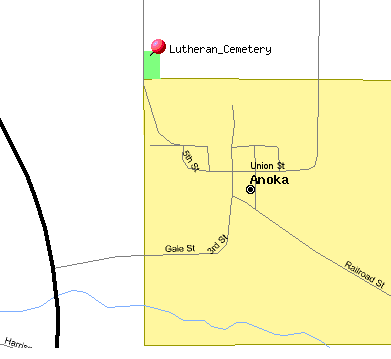
| Anoka Lutheran Cemetery Cemetery added to original list |
Cemetery | Boyd | Map | Anoka, Nebraska |
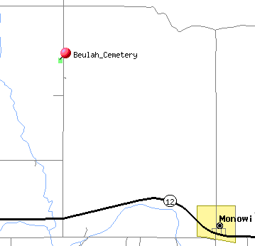
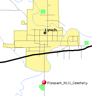
| Beulah Cemetery | Cemetery | Boyd | Map | Located 5 miles east and 2 miles north of Lynch. Land given by E A Smith.(names in file) |
| Bohemian National Cemetery | Cemetery | Boyd | Located Lynch, Nebr. (Names in file) | |
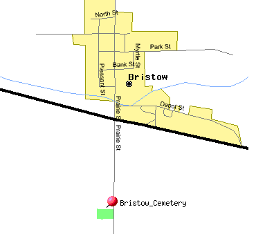
| Bristow Cemetery Cemetery added to original list |
Cemetery | Boyd | Map | Plot Map |
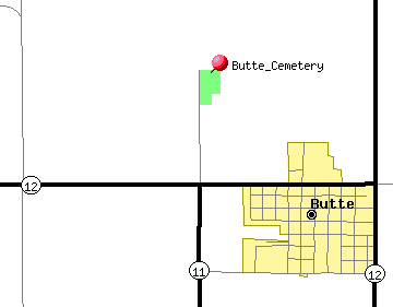
| Butte Cemetery Cemetery added to original list |
Cemetery | Boyd | Map | |
| Cemetery near Henry Bruner Place |
Cemetery | ?? | most graves never marked | |
| Catholic Cemetery, Lynch | Cemetery | Boyd | In Lynch, land belonged to John and Hannah Lynch and George and Josephine Nagengast.(names in file) | |
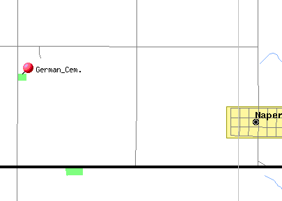
| German Cemetery Cemetery added to original list |
Cemetery | Boyd | Map | |
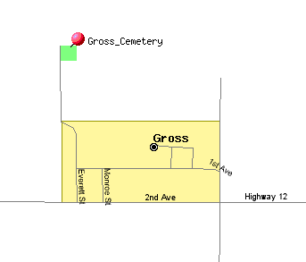
| Gross Cemetery (2007 transcription & photos) Gross Cemetery (Partial index) |
Cemetery | Boyd | Map | |
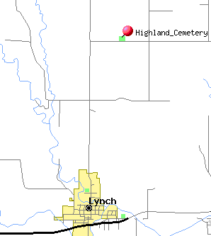
| Highland Cemetery | Cemetery | Boyd | Map | Located 3 miles north and ½ miles east of Lynch. Land given by Arthur C Gray |
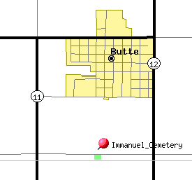
| Immanuel Cemetery Cemetery added to original list |
Cemetery | Boyd | Map | South of Butte, Nebraska |
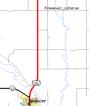
| Immanuel Lutheran Cemetery NEW!! Cemetery added to original list |
Cemetery | Boyd | Map | four and half miles north of Spencer, Nebraska, turn east about 1/2 miles |
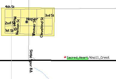
| Knoll Crest Cemetery 2007 Knoll Crest Cemetery 2006 Sacred Heart Cemetery Lost Airmen Memorial |
Cemetery | Boyd | Map | Naper, Nebraska |
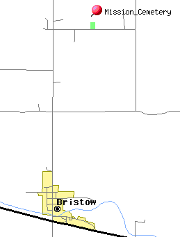
| Mission Cemetery Cemetery added to original list |
Cemetery | Boyd | Map | North of Bristow, Nebraska |
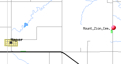
| Mount Zion Cemetery Cemetery added to original list |
Cemetery | Boyd | Map | |
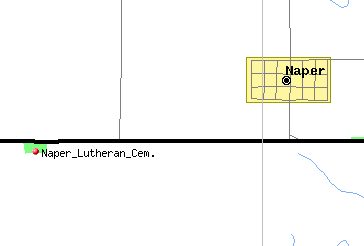
| Naper Lutheran Cemetery | Cemetery | Boyd | Map | |
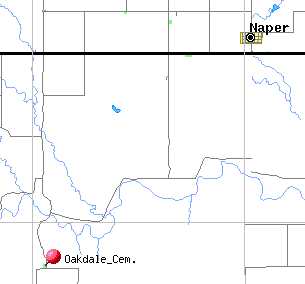
| Oakdale Cem | Cemetery | Boyd | Map | Located in Boyd County now, 14 miles above the mouth of the Keya Paha River where it empties into the Niobrara. John Munt came in June of 1879, his child, John C Munt, was the first child born there, Oct 10,1880. |
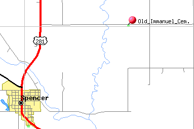
| Old Immanuel Cemetery Cemetery added to original list |
Cemetery | Boyd | Map | Northeast of Spencer, Nebraska |
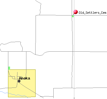
| Old Settlers Cemetery Second Transcription (Cemetery added to original list) |
Cemetery | Boyd | Map | Northeast of Anoka, Nebraska |
| Pleasant Hill Cemetery NEW!! | Cemetery | Boyd | Map | Located south of Lynch, land part of John Higgins farm |
| Pleasant View Cemetery | Cemetery | Boyd | Located 6 miles north of Lynch. Land belonged to John H Chambers | |
| Riha Cemetery | Cemetery | Boyd | Located 3 miles south, 1 mile east ½ mile north of Monowi | |
| Rosedale Covenant Cemetery Cemetery added to original list |
Cemetery | Boyd | ||
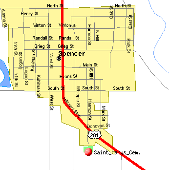
| St. Mary's Cemetery Cemetery added to original list |
Cemetery | Boyd | Map | Spencer, Nebraska |
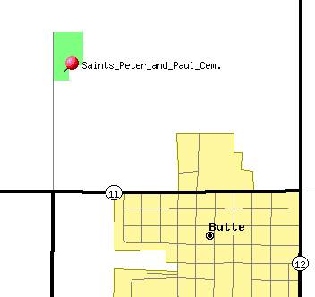
| Saint Peter and Paul Cemetery Cemetery added to original list |
Cemetery | Boyd | Map | Butte, Nebraska |
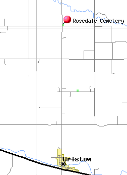
| Trinity Lutheran Church Cemetery once known as Rosedale Evangelical Cemetery |
Cemetery | Boyd | Map | 4 mi N of Bristow, NE |
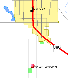
| Union Cemetery Cemetery added to original list |
Cemetery | Boyd | Map | Spencer, Nebraska |
| Unnamed Cemetery | Cemetery | ?? | This cemetery is located in the middle of a pasture and has a fence around it. Several of the stones are broken. Location: T-31-N Belle R-13-W | |
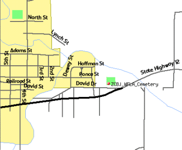
| ZCBJ WFLA Cemetery - NEW!! Bohemian National Cemetery |
Cemetery | Boyd | Map | Lynch,Nebr on north side of the highway just east of Lynch |
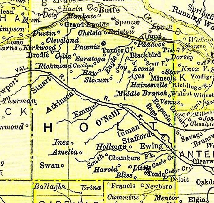 Holt County 1895 (Image is a link to a larger version) |
| Feature Name | Feature Type | County | Map | Notes |
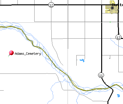
| Adams Cemetery |
Cemetery | Holt | Map | Latitude: 42.8705551 Longiture: -98.9695374 |
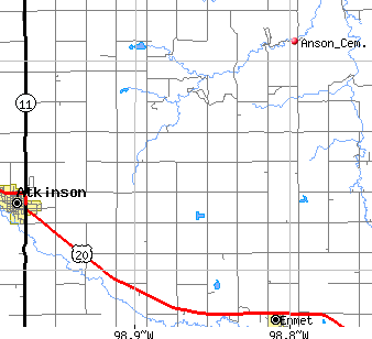
| Anson's Cemetery Found in the Holt County NEGenWeb Project |
Map | Holt | located 882 Road, 485 Ave - 9 miles east of Atkinson, 5 miles north | |
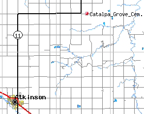
| Catalpa Grove Cemetery Found in the Holt County NEGenWeb Project |
Cemetery | Holt | Map | Nw corner of NE ¼ section 21, township 31, range 13 near the post offices of Catalpa and Richmond. |
| Cedar Lawn Cemetery Old Paddock Cemetery |
Cemetery | Holt | Sw ¼ of se ¼ section 1 township 32 range 11 James W Ross first postmaster of Cedar Lawn postoffice. | |
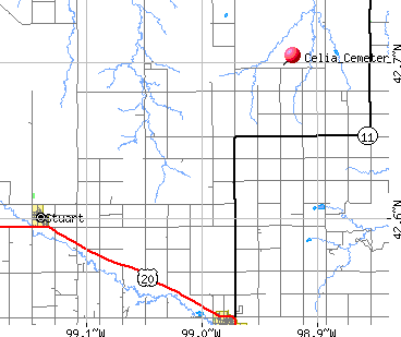
| Celia Cemetery Celia Cemetery Found in the Holt County NEGenWeb Project |
Cemetery | Holt | Map | Celia Cemetery is in township 31-32 north Sand Creek Dustin precinct R 14W Victor Frickel owns the land. NW ¼ of NW ¼ , section 2, township 31, range 14 |
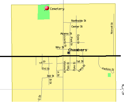
| Chambers Cemetery Cemetery added to original list Chambers War Memorial Transcription in the Holt County ALHN Project |
Cemetery | Holt | Map | Chambers, Nebraska |
| Chelsea Cemetery | Cemetery | Holt | Section 19, township 32, range 19, near Chelsea post office, J Blackmore first post master, in dug out home of Haskel, 1902 moved to Hugh O'Neill home, then called Anncar. | |
| Cherry Hill Cem | Cemetery | Holt | Map | Now the Page Cemetery |
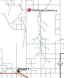
| Cleveland Union Cem | Cemetery | Holt | Map | SE ¼ of NE ¼ section 6, township 32, range 15 |
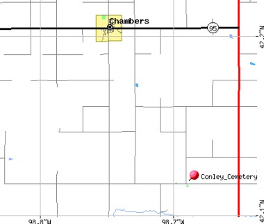
| Conley Cemetery Conley Cemetery** **Transcription in the Holt County ALHN Project |
Cemetery | Holt | Map | 6 miles south and 2 ½ miles east of Chambers, not all the markers are readable NW ¼ of NW ¼, section 26, township 25, range 12 4 ½ miles west of Conley on a hill, 8 headstones, only one with writing |
| Disney, Nebraska | Town | Holt | Disney was 2 miles southwest of Opportunity. | |
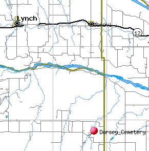
| Dorsey Cemetery Dorsey Cemetery Transcription in the USGenWeb Archives Project (Apple Creek) |
Cemetery | Holt | Map | NE ¼ of SW ¼, section 11 township 31 range 9 |
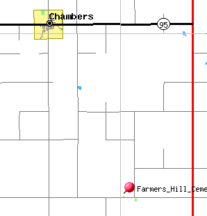
| Farmers Hill Cemetery Farmers Hill Cemetery** **Transcription in the Holt County ALHN Project |
Cemetery | Holt | Map | Conley Township, SW ¼ of SE ¼, section 22, township 25, range 12 6 miles south of Chambers 2 ½ miles east |
| Ford, Nebraska | Town | Holt | The City of Ewing was known as “Ford”previously. | |
| Hainesville Cemetery Transcription in the USGenWeb Archives Project |
Cemetery | Holt | Hainesville CEMETERY (Willowdale Township), near O'Neill, Holt County, Nebraska Hainesville no longer exists. To reach this cemetery, take Highway 108 east out of O'Neill, NE. The highway will fork to the right - take an old oil country road to the left for appoximately 10 miles (6 heading north, then 4 heading east). The cemetery is located in an alfalfa field, 1/2 mile in from the road. It is surrounded by barb wire fencing. | |
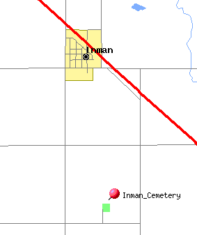
| Inman Cemetery Transcription in the Holt County ALHN Project |
Cemetery | Holt | Map | This cemetery is located in Holt County, Nebraska, south of Inman, on a hill. There is a paved road leading from town to the cemetery. about 3 miles NW corner of SW ¼, section 32, township 28, range 10 |
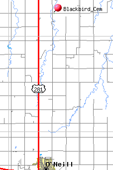
| Blackbird Cemetery Also Known as Joy Cemetery |
Cemetery | Holt | Map | 10 (11) miles north and one and ½ miles east of O'Neill, Nebr. NE ¼ of NW ¼, section 32, township 31, range 11 The Postoffice of Joy had a post office, black smith shop, and general store. After 1914 became known as Blackbird. |
| Kezar - Darnell | Cemetery | Holt | NE ¼ section 34 township 31 range 9 | |
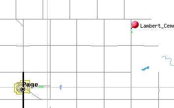
| Lambert Cemetery | Cemetery | Holt | Map | 1 and ½ miles north of Page, 4 miles east and ½ mile north on the east side of the road. NW corner of SW ¼, section 2, township 28, range 9 |
| Little, Nebraska | Town | Holt | Name was changed to Martha | |
| Lone Pine Tree Cemetery | Cemetery | Holt | North of the Hutn Place about 1 and ½ miles south of Page. | |
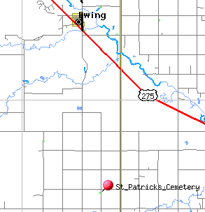
| Lutheran Cemetery Ziems Cem (St. Patrick's) Transcription in the Holt County ALHN Project |
Cemetery | Holt | Map | South and east of Chambers, NW ¼ of SW ¼, section 4,township 25, range 9 |
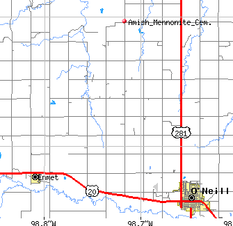
| Mennonite Cemetery Found in the Holt County NEGenWeb Project |
Cemetery | Holt | Map | located north of O'Neill, west on Highway 281 4 miles to gravel road (489 Ave), turn right follow road north to Cem (Rd 881) |
| Mineola Cemetery (Miniola) Found in the Holt County NEGenWeb Project |
Cemetery | Holt | Map | Located northwest quarter of northwest quarter of section two township 30 range 10. Original started 1886. The city of Mineola was located 6 miles northeast of Opportunity or 7 miles from Niobrara. |
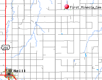
| Powell Grove Cem (First Mineola Cem) Found in the Holt County NEGenWeb Project |
Cemetery | Holt | Map | ½ mile west of the larger cem, Section 3, township 30, range 10 |
| Mohr Cem Hainesville Cem |
Cemetery | Holt | NW ¼ of SW ¼ Section 24, township 30, range 9 1 mile north of Ash Grove Hall. | |
| Negro Cemetery | Cemetery | Holt | Near Goose Lake, some graves were moved to Trussell Cem. | |
| Opportunity, Nebraska | Town | Holt | Located 9 miles west of Hainesville | |
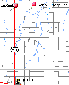
| Paddock Union Cemetery - found in the Holt County NEGenWeb Project. Additional transcription: Paddock Union Cem - in the Holt County ALHN Project |
Cemetery | Holt | Map | SE ¼, section 3, township 31, range 11 |
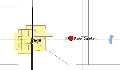
| Page Cemetery Cherry Hill Cemetery |
Cemetery | Holt | Map | |
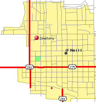
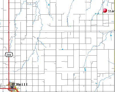
| O'Neill Cemetery Prospect Hill Cemetery Prospect Cemetery Calvary Cemetery Transcription in the Holt County ALHN Project |
Cemetery | Holt | Map | This cemetery is north of O'Neill, along the highway 281. The Catholic graves are parallel to the highway. This cemetery is located in Holt County, Nebraska, just north of the town of O'Neill, across from the golf course. The Historical Society, located at the Old Bank Building on Main Street at the stop light on Highway 20 across from the Golden Hotel, in O'Neill has a map showing where graves before 1976 are located. Contact them for the exact location in a cemetery. |
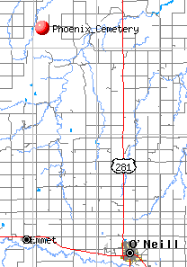
| Phoenix Cemetery Found in the Holt County NEGenWeb Project |
Cemetery | Holt | Map | is located in South Saratoga Township, northwest quarter of northeast quarter 25-32-13. Leave O'Neill on highway 281, going north 18 to 19 miles, cross Eagle Creek, turn west on that road. The land was deeded by Hans and Catherine Storjohann, east quarter, Saratoga Township, northwest quarter of northeast quarter and northeast quarter of northwest quarter in 25-32-13. Nov 22,1918 there were ten Storjohann families. |
| Pine Valley Cemetery | Cemetery | Holt | North west half of northwest quarter section nineteen township twenty five range fifteen One mile south of grove of pines planted by Bruner Brothers, in a sand blow out. | |
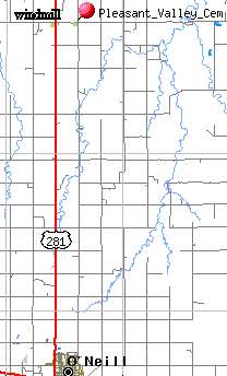
| Pleasant Valley Cemetery Found in Holt County NEGenWeb Project |
Cemetery | Holt | Map | These two cemeteries are located in Holt County, Nebraska. They are about 14 miles north of O'Neill, then about 1 miles east. There are two cemeteries on this road about ¼ mile apart, Paddock and Pleasant Valley. Pleasant Valley cemetery was established in 1890 On the gate of the Paddock Union Cemetery are the following words: “In memory of Hon Frank Nelson State Sen 1949-1966” Pleasant Valley- NE ¼ of NE ¼ Section 7, township 31, range 11 |
| Paddock Union Cemetery Found in Holt County NEGenWeb Project |
Cemetery | Holt | Map | |
| Prairie Home Cem Found in Holt County NEGenWeb Project |
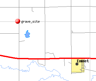
Cemetery | Holt | Map | NW ¼ of SW ¼, section 11, township 29, range 13, 1 ½ miles northwest of Emmet 2 stones left standing. Emmet Cem |
| Prospect Hill Cem | Cemetery | Holt | SW 1/3 section 2 township 30 range 11 | |
| Reimer - Wulf Cem | Cemetery | Holt | Map | NW ¼ of SW ¼ section 26 township 25 range 9 |
| Small Rural Cemetery | This small plot is on private land. You will need to get permission from the owner before visiting. This small cemetery is on a hill over looking the Niobrara River. Go straight north of O'Neill, till just about a mile from the river, turn west and follow the road, at the house, go into the pasture and in one of the small grove of trees is this cemetery. | |||
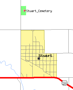
| Stuart Community Cemetery* St. Boniface Cemetery* *Transcription in Holt Co. NEGenWeb Project St. Boniface Cemetery** **Transcription in the Holt County ALHN Project Cemetery added to original list |
Cemetery | Holt | Map | Stuart, NE |
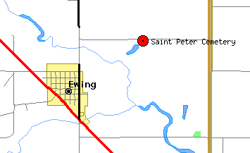
| Saint Peter Cemetery Cemetery added to original list |
Cemetery | Holt | Map | Northeast of Ewing, Nebraska |
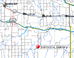
| Scottville Cemetery Scottville Cemetery Transcription in the Holt County ALHN Project |
Cemetery | Holt | Map | Section 5 township 31 range 10 |
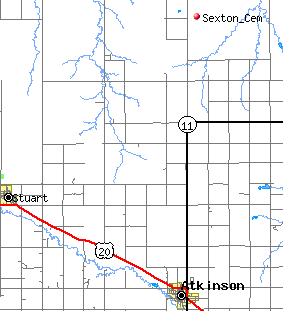
| Sexton | Town | Holt | Near Dustin, Nebr | |
| Sexton - Adams Found in the Holt County NEGenWeb Project |
Cemetery | Holt | Map | SE ¼ of SW ¼ section 33 township 34 range 14 |
| Shamrock, Nebraska | Town | Holt | 4 miles north of Chambers | |
| Stafford, Nebraska | Town | Holt | was 8 miles northwest of Ewing | |
| Star Cem | Cemetery | Holt | Map | SW corner section 23 township 31 range 9 |
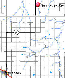
| Sona View - Sunnyview Cemetery Found in the Holt County NEGenWeb Project |
Cemetery | Holt | Map | 1874-1902 located north of Atkinson, along the highway to Butte. SW ¼ of SW ¼ section 21 township 32 range 13 16 miles northeast of Atkinson on Highway 11 |
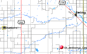
| St Anthonius Cem Saint Anthony's |
Cemetery | Holt | Map | SW ¼ of NW ¼ section 25 township 25 range 9 |
| St Patrick's Cem | Cemetery | Holt | Map | NE ¼ of NE ¼ section 23 township 25 range 9 |
| Unnamed cem | Cemetery | Holt | Southwest of Chambers, a Catholic Church and Cemetery, church was moved. Section 30 township 25 range 19, fence surrounds cemeter | |
| Unnamed Cem | Cemetery | Holt | SW ¼ of SW ¼ section 15 township 30 range 11 John Kayle perished in blizzard of Jan 12,1888, buried here. July 12,1889 Peter Kayle deeded 10 acres to James O'Connor. | |
| Unnamed cem | Cemetery | Holt | John Welsh place, at corner adjacent to the State Road Park near Atkinson, one tombstone, John Welsh. | |
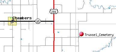
| Valley View Cemetery Trussell Cemetery |
Cemetery | Holt | Map | NW ¼ of NW ¼ section 3 township 25 range 11 South and east of Chambers Black people from the Lake City Cem were interred here when the bones were uncovered by wind. |
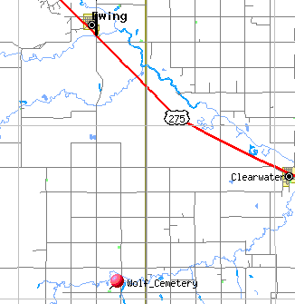
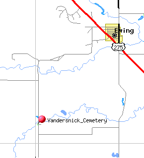
| Vandersnick Cemetery | Cemetery | Holt | Map | 6 miles south west (east) of Ewing Near south bank of Cache Creek section 19 township 29 range 9 |
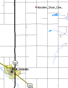
| Wooden Shoe Cemetery Transcription in the Holt Co. NEGenWeb Project |
Cemetery | Holt | Map | cemetery, most of the graves were moved to Atkinson later. Located on Fred Jansen's land, two miles east and five miles north of Atkinson. Surrounded by lilac bushes. |
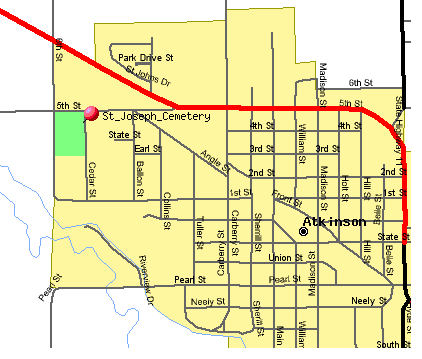
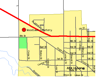
| St. Joseph Cemetery* Woodlawn Cemetery* *Transcription in the Holt County NEGenWeb Project Woodlawn Cemetery** St. Joseph Cemetery** **Transcription in the Holt County ALHN Project |
Cemetery | Holt | Map 1 Map 2 |
Located in Atkinson, Nebraska, just west of town along highway 20. There are two cemeteries, Woodlawn is north of the road running through the cemeteries. St Joseph is south of the road. |
| Wulf-Reimer Cemetery Transcription in the Holt County ALHN Project |
Cemetery | Holt | Map | Grandfather Broer planted trees on Wulf farm to show where he wanted to be buried |
| Feature Name | Feature Type | County | Map | Notes |
| Florence Cem - see Lee Cem |
Cemetery | Antelope | ||
| Lee Cemetery | Cemetery | Antelope | Northwest corner of NE ¼, section 12, township 27,range 9 ½ mile west of the Holt Antelope County line | |
| Grandview-Long Pine Cem | Cemetery | Brown | Current cemetery is located 1 mile south of Long Pine. The first cemetery in Long Pine was located 1/4 mile east of Long Pine near the Railroad tracks. It was discontinued on Sept. 1,1888. Some of graves were moved to the new south cemetery and some were just left and abandoned with stones removed and lost. Some of the remaining bodies left at the old cemetery were not allowed to be moved because of death due to contagious disease. Anyone dieing before 1888 was buried in the old cemetery, and after Sept 1,1888 in the new cemetery. It was first opened for the buried of C.T. Bannining who was the first interment there. There was no location given for that burial. Legal Description: NW SE Section 31, Township 30, Range 20 | |
| Grimton Cemetery Transcription found in the Knox County NEGenWeb project cemetery listings. |
Cemetery | Knox | Walnut Grove Township, North east quarter section 32-29-8 | |
| Sybrant Cemetery | Cemetery | Rock | 8 miles south of Bassett on Highway 183 east 13 miles to end of oil and ½ mile east 1 mile south ½ mile west 1 miles south west across the pasture diagonally, no road |