History of Buffalo County
CHAPTER I
BEFORE THE WHITE MAN CAME--NAMES OF INDIAN TRIBES INHABITING NEBRASKA TERRITORY--BRIEF HISTORY OF THE PAWNEE INDIANS--FAITHFUL TO THEIR TREATY OBLIGATIONS--REMOVAL TO INDIAN TERRITORY IN 1876--ASSIGNED LANDS IN SEVERALTY IN 1892--A PATHETIC INCIDENT--IN 1915 THE PAWNEE MAKING GOOD, BECOMING USEFUL CITIZENS
BEFORE THE WHITE MAN CAME
Before the white man came this land we call "Nebraska" was claimed by several tribes of Indians. The boundaries of their lands were not defined by metes and bounds, clearly outlined and made matters of record, as are the counties of the state. In the eighteenth annual report of the Bureau of American ethnology, for the years 1896-97, J. W. Powell, director, is given an outline map of Nebraska, giving the names of the principal tribes of Indians, the location of their lands in the state and the dates when each tribe ceded such lands to the general Government. Herewith is a brief summary from said report, giving the names of the tribes and the location of their lands. The State of Nebraska is approximately two hundred miles from north to south and four hundred from east to west. Speaking in a general way, not to be understood as being exact, let us draw a line across a map of Nebraska commencing at the mouth of the Niobrara River, thence south about sixty miles, thence southeast to a point east of the City of Columbus, thence south to the Kansas State line. East of this line to the Missouri River and north of the Platte River the lands thus embraced were those claimed by the Omaha Indians and tribes friendly to and living within the territory described. East of this line to the Missouri River and south of the Platte River, the lands thus embraced were those of the Oto and Missouri tribes.
Next let us draw a line north and south across the state, passing through the forks of the Platte River--North Platte. The territory thus embraced between these two lines, the central portion of the state, both north and south of the Platte River, were lands belonging to the confederated tribes of Pawnee Indians, viz.: Grand Pawnee, Pawnee Loup, Pawnee Republicans and Pawnee Tappaye.
West of the Pawnees and south of the Platte the lands were claimed by the Arapaho and Cheyenne tribes. West of the Pawnees and north of the Platte
Vol. I -1
2
HISTORY OF BUFFALO COUNTY
were the lands of the Sioux, and in the northern part those of the Sioux, Northern Cheyennes and Arapaho.
It will be seen that Buffalo County is located in what was Pawnee territory, without question the greatest hunting ground on the American continent for wild game, such as buffalo, elk, deer and antelope. The Pawnee lands south of the Platte were ceded to the general Government October 9, 1833- The Fort Kearney Military Reservation, .north of the Platte, was ceded to the general Government August 6, 1848, and the remaining lands of the Pawnees, north of the Platte, were ceded September 24, 1857.
How long the Pawnee Indians had inhabited the valleys of the Platte and Loup rivers in what we now call Nebraska is not definitely known, and doubtless never will be, but history seems to disclose that they were living here more than three centuries before the white man came to dispossess them, about the year 1860.
The following brief history of the Pawnee, whose lands we, the people of Buffalo County, Nebraska, now occupy and enjoy, is taken as an extract (kindly furnished by United States Senator George W. Norris) from the "Handbook of American Indians," Bulletin No. 30, Bureau of American Ethnology:
"Pawnee. A confederacy belonging to the Caddoan family. The name is probably derived from Pariki, a horn, a term used to designate the peculiar manner of dressing the scalp-lock, by which the hair was stiffened with paint and fat, and made to stand erect and curved like a horn. This marked feature of the Pawnee gave currency to the name and its application to cognate tribes. The people called themselves Chahiksichahiks, 'men of men.'
"In the general northeastwardly movement of the Caddoan tribes the Pawnee seem to have brought up the rear. Their migration was not in a compact body, but in groups, whose slow progress covered long periods of time. The Pawnee tribe finally established themselves in the Valley of the Platte River, Nebraska, which territory their traditions say was acquired by conquest, but the people who were driven out are not named. It is not improbable that in making their way northeast the Pawnee may have encountered one or more waves of the southward movements of Shoshonean and Athapascan tribes. When the Siouan tribes entered the Platte Valley they found the Pawnee there. The geographic arrangement always observed by the four leading Pawnee tribes may give a hint of the order of their northeastward movement, or of their grouping in their traditionary southwestern home.
"The Skidi place was to the northwest, and they were spoken of as belongingto the upper villages. The Pitahauerat villages were always downstream; those of the Chaui, in the middle, or between the Pitahauerat and the Kitkehahki, the villages of the last named being always upstream. How long the Pawnee resided in the Platte Valley is unknown, but their stay was long enough to give new terms to 'west' and 'east;' that is, words equivalent to 'up' or 'down' that eastwardly flowing stream.
"The earliest mention of a Pawnee is that of the so-called 'Turk' (q. v.), who, by his tales concerning the riches of Quivira (q. v.), allured and finally led Coronado, in 1541, from New Mexico over the plains as far as Kansas, where some Pawnee (see Harahey) visited him. The permanent villages of the tribes
3HISTORY OF BUFFALO COUNTY lay to the north of Quivira, a name given to the Wichita territory. It is doubtful if the Apane or the Quipana mentioned in the narrative of De Soto's expedition in 1541 were the Pawnee, as the latter dwelt to the northwest of the Spaniard's line of travel. Nor is it likely that the early French explorers visited the Pawnee villages, although they heard of them, and their locality was indicated by Tonti, La Harpe and others. French traders, however, were established among the tribes before the middle of the eighteenth century.
"How the term Pani (q. v.) or Pawnee, as applied to Indian slaves, came into use is not definitely known. It was a practice among the French and English in the seventeenth and eighteenth centuries to obtain from friendly tribes their captives taken in war and to sell them as slaves to white settlers. By ordinance of April 13, 1709) the enslavement of negroes and Pawnee was recognized in Canada (Shea's Charlevoix, v. 224, 1871). The Pawnee do not seem to have suffered especially from this traffic, which, though lucrative, had to be abandoned on account of animosities it engendered. The white settlers of New Mexico became familiar with the Pawnee early in the seventeenth century through the latter's raids for procuring horses, and for more than two centuries the Spanish authorities of that territory sought to bring about peaceful relations with them, with only partial success.
"As the Pawnee lay in a country remote from the region contested by the Spaniards and French in the seventeenth and eighteenth centuries, these Indians escaped for a time the influences that proved so fatal to their congeners, but ever-increasing contact with the white race, in the latter part of the eighteenth century, introduced new diseases and brought great reduction in population, together with loss in tribal power. When the Pawnee territory, through the Louisiana Purchase, passed under the control of the United States, the Indians came in close touch with the trading center at St. Louis. At that time their territory lay between the Niobrara River on the north and Prairie Dog Creek on the south, and was bounded on the west by the country of the Cheyenne and Arapaho, and on the east by that of the Omaha, on .the north of the Platte River, and on the south of the Platte by the lands of the Oto and Kansa tribes. The trail to the southwest, and later across the continent, ran partly through Pawnee land, and the increasing travel and the settlement of the country brought about many changes. Through all the vicissitudes of the nineteenth century the Pawnee never made war on the United States. On the contrary, they gave many evidences of forbearance under severe provocation by waiting, under their treaty agreement, for the Government to right their wrongs, while Pawnee scouts faithfully and courageously served in the United States army during Indian hostilities.
"The history of the Pawnee has been that common to reservation life--the gradual abandonment of ancient customs and the relinquishment of homes before the pressure of white immigration.
"* * * By treaty of Table Creek, Neb., September 24, 1857, all lands north of the Platte River were assigned to the Government except a strip on the Loup River, thirty miles east and west and fifteen miles north and south, where their reservation was established. This tract was ceded in 1876, when
4HISTORY OF BUFFALO COUNTY the tribes were removed to Oklahoma, where they now live. In 1892 they took their lands in severally and became citizens of the United States. * * *
"In 1702 the Pawnee were estimated by Iberville at two thousand families. In 1838 they numbered about ten thousand souls, according to an estimate of houses by Missionaries Dunbar and Allis, and the estimate is substantially confirmed by other authorities of the same period, one putting the number as high as twelve thousand five hundred. The opening of a principal emigrant trail directly through the country in the 40's introduced disease and dissipation, and left the people less able to defend themselves against the continuous attacks of their enemies, the Sioux.
"In 1848 they were officially reported to have lost one-fourth of their number by cholera, leaving only 4,500. In 1856 they had increased to 4,686, but five years later were reported at 3,416. They lost heavily by removal to Indian Territory in 1873-75; and in 1879 numbered only 1,140. They have continued to dwindle each year until there are now (1906) but 649 surviving."
What a sad history the foregoing is of a people who for centuries possessed and successfully defended this land in Central Nebraska which we now possess and enjoy! What a sad history of a people of whom it is written that they faithfully observed their treaty agreements with the United States and loyally and courageously fought in the armies of the United States against its enemies!
It is related that after the removal of the Pawnee to the Indian Territory in 1876 (much against their wish, many being brutally compelled to go by the soldiers assigned to their removal) that some of the number became so homesick that in the dead of winter they stole away from the reservation and journeyed back to Nebraska in order to once more visit the land of their fathers, to visit their former homes and the places where their dead were buried--and what did they find? Their former homes, the burial places of their dead, were plowed fields, the home of the white man. There was no place they could go and be welcome. They were, as it might be said, a stench in the nostrils of the white man, and the soldiers of our Government, armed with guns and bayonets, forced them to return to the reservation assigned them.
And thus it was that we, the white men, came and possessed this land.
In the year 1915, H. A. Lee, an early settler and long-time resident of Buffalo County, now residing in Oklahoma, writes that the Pawnee are making good; tilling their farms, establishing homes, making useful citizens.
5CHAPTER II
FORT KEARNEY--DATE WHEN ESTABLISHED-BOUNDARIES OF MILITARY RESERVATION--BLEW THE BUGLE--REFERENCE--HISTORY OF FORT KEARNEY BY ALBERT WATKINS, HISTORIAN OF STATE HISTORICAL SOCIETY--SERGEANT MICHAEL COADY--A SOLDIER OF THE MEXICAN AND CIVIL WARS--SERVED AS CLERK OF BUFFALO COUNTY--CHARTER MEMBER OF FIRST I. O. O. F. LODGE INSTITUTED IN THE COUNTY--CHARTER MEMBER OF FIRST MASONIC LODGE INSTITUTED IN THE COUNTY
FORT KEARNEY
(Note-In Volume No. 16 of the published collections of the Nebraska State Historical Society, for the year 1911, may be found a very complete history of Fort Kearney compiled from public documents and written by Albert Watkins, historian of the State Historical Society.)
As a protection to the thousands of emigrants traveling the Oregon and Overland trails from the early '30's to the completion of the Union Pacific Railroad in 1869, Fort Kearney was established in May, 1848, and garrisoned with United States troops "Until its abandonment in the year 1871. That portion of the military reservation on the north side of the Platte River and in part within the boundaries of Buffalo County was ceded to the general Government in 1848 and its boundaries described as follows:
"Commencing on the south side of the Platte River, five miles west of post 'Fort Childs' (later named Fort Kearney), thence due north to the crest of the bluffs north of said Platte River; thence east and along the crest of saids [sic] bluffs to the termination of Grand Island, supposed to be about sixty miles distant; thence south to the southern shore of said Platte River; and thence west and along the southern shore of said Platte River to the place of beginning.
"A plat of this tract is inserted in the treaty."
The reservation on which the fort was located was ten miles square, lying on both sides of the Platte River, and over this reservation a strict military discipline was maintained. While emigrants were permitted to travel the trails crossing the reservation and to visit the fort, no one was permitted to make an overnight camp on this reservation. To this there was one exception--to encourage the raising of crops, more especially gardens, small tracts of land were leased to individuals who were permitted to reside upon such leased tracts. The tracts thus leased were located on islands of the Platte, principally an island known as Fort Farm Island. Also on this island some farming, such as growing corn, was done under the supervision of the military authorities at the fort. Also on
6HISTORY OF BUFFALO COUNTY this island a considerable area was fenced for pasture for horses belonging to the garrison.
It is understood that the reason for including in the military reservation the tract above noted--some sixty miles in length and embracing, as it did, the Wood River Valley in Buffalo County--was that on this tract, which included the "thousand" islands of the Platte, there was much timber needed and used by the military authorities.BLEW THE BUGLE
It is related that each day an officer and guard were detailed to visit the timber sections of the reservation and see if unauthorized persons were cutting Government timber. It is also related that on such duty, at intervals, the clear notes of a bugle rang out over the islands and the prairie, and hearing the bugle unauthorized wood choppers ceased from their labors while the inspection guard passed by. On return to the fort the officer reported that he saw no one engaged in cutting timber on, the reservation, and yet as the years came and went, and before the fort was finally abandoned, the islands of the Platte and the banks of Wood River within the bounds of the reservation were entirely stripped of timber suitable for cordwood or a railroad tie.
It should also be mentioned that this timbered reservation furnished all timber needed for fuel and other purposes at the fort for some twenty-three years.SERGT. MICHAEL COADY
The name of Sergt. Michael Coady and mention of his deeds is well worthy a place and to be made of record in a history of Buffalo County, although in a legal sense it can hardly be said he was ever a resident of the county. Sergeant Coady was kind and helpful to early settlers in Central Nebraska when kindness on the part of those in authority was appreciated and help needed.
Early settlers could not tell the names of the commanding officers at Fort Kearney, but every man, woman and child knew of Sergeant Coady, that he seemed to exert much authority and that he was a friend to all pioneer settlers.
It will be noted in this history of Buffalo County that Sergeant Coady was active in the reorganization of the county in 1870, and that he was elected and served as county clerk. It is related that when the first elections were held in the reorganized county, the poll books were taken to Fort Kearney, and Sergeant Coady helped to make out the election returns, for the reason that Sergeant Coady was accustomed to making reports, the keeping of records, while the residents of the county were not. It will be noted, in this history, that Michael Coady was a charter member, helped to organize the first I. O. O. F. lodge instituted in the county in 1873. It will also be noted that he was a charter member, and helped to organize the first Masonic lodge in the county in 1873.
Sergeant Coady was of a sociable disposition, and enjoyed a wide acquaintance both in army circles and in the state.
While he was forceful, energetic, a born fighter, he was of a most kindly disposition. It is related that Sergeant Coady was offered a commission as officer
7HISTORY OF BUFFALO COUNTY in the regular army of the United States and declined, giving as his reason that his early advantages and training were such that were he an officer, invited to social functions, his brother officers might feel humiliated, while if not invited he should feel offended.
"Leave me be a sergeant," he is reported to have said, "and I'll be satisfied," and a sergeant to the end of his army days he was.
When, as a military post Fort Kearney was abandoned in 1870, Sergeant Coady was left in command, in charge of the Government property until August, 1874, when he was ordered to take station at Fort Omaha, Neb., where, in addition to his duties as ordnance sergeant, he was postmaster of the fort. After his retirement from the army he remained postmaster at the post until it was abandoned in 1896, when he moved out of the post and settled down, living a quiet life until his death, September 10, 1900.
He was accorded a military funeral with full honors due a commissioned officer.
Michael Coady was born January 1, 1828, in Tipperary, Ireland, and when a small boy emigrated to America. He entered the United Staves army in 1846, serving through the Mexican war, Rebellion and numerous Indian campaigns.
In 1862 Sergeant Coady was appointed ordnance sergeant, which position he held until he was retired, June 16, 1885.
He was married in July, 1860, at Washington, D. C.
There were born to Mr. and Mrs. Coady five daughters, Julia, Mary, Margaret Elizabeth, Anna, and Catherine; three sons, John J, Edward V, and William F. In 1916 his widow and living children were residents of Omaha.
The following is a list of battles in which Sergeant Coady participated:
Palo Alto 1846 Rasaca de la Palma 1846 Monterey 1846 Vera Cruz 1846 Contreras and Cherubusco 1846 Molino del Rey 1846 City of Mexico 1846
Indian campaigns in New Mexico and Texas and the Overland boundary survey, from 1848 to 1860.BATTLES OF THE REBELLION
First and Second Bull Run 1862 Savage Station 1862 Glen Dale 1862 White Oak Swamp 1862 Glen Mills 1862 Hanover Courthouse 1862 Malvern Hill 1862 Charles City Cross Roads 1862 Mechanicsville 1862
8HISTORY OF BUFFALO COUNTY
Discharges bear the following characters: "Excellent in every respect. Remarks: His performance of every duty marked by the same faithfulness and zeal which has always characterized him."
Discharges signed by the following officers: Gen. John Gibbon, Dangerfield Parker, John H. King, William P. Carlin, Edwin Pollock and others.
9CHAPTER III
BUFFALO COUNTY; HALL COUNTY--IN TERRITORIAL DAYS HALL COUNTY OFFICIALS TRANSACT THE FINANCIAL AFFAIRS OF BUFFALO COUNTY--EQUALIZE ASSESSMENT OF PROPERTY; LEVY TAXES; COLLECT TAXES; AUDIT AND PAY CLAIMS AGAINST BUFFALO COUNTY--COPIES OF DUPLICATE TAX RECEIPTS--LIST OF TAX PAYERS IN BUFFALO COUNTY WHO PAID THEIR TAXES TO THE TREASURER OF HALL COUNTY
BUFFALO COUNTY; HALL COUNTY
While there are records and publications (election returns in the office of the secretary of state, special legislation relating to Buffalo County, a proclamation in the office of the governor, copies of the Huntsman's Echo in the library of the state historical society) which seem to disclose that there was a county organization in Buffalo County, dating possibly from the year 1855, quite certainly from the year 1858, and that a complete list of county officials were elected in and for Buffalo County, and while these officers doubtless did on occasions act in an official capacity, yet there are no county records of Buffalo County of an earlier date than the year 1870, and so far as the writer has knowledge, the only records relating to the conduct of county business in Buffalo County previous to 1870 are the county records of Hall County. The county records of Hall County date from 1858, the year the county was organized, and these records seem to disclose that while the political existence of Buffalo County was recognized, that the county business of and for Buffalo County was transacted by the officials of Hall County. It appears that the county commissioners of Hall County audited and allowed the claim of the assessor of property in Buffalo County and ordered the same paid out of the general fund of Buffalo County.
It appears that the commissioners of Hall County equalized the assessment of property in Buffalo County at the same meeting as was equalized the assessment of property of Hall County, and then proceeded to make the levy of taxes in and for Buffalo County. It appears from records in the treasurer's office of Hall County that taxpayers in Buffalo County paid their taxes to the treasurer of Hall County, who issued receipts therefor, the duplicate tax receipt showing it was for taxes due Buffalo County.
The proceedings of the county commissioners of Hall County disclose that when a term of court was held at Grand Island, the expense of said term of court was paid out of the general fund of both Hall and Buffalo counties. In considering this matter it should be kept in mind that in territorial days in Nebraska, there were but few people residing in either Buffalo or Hall County;
10HISTORY OF BUFFALO COUNTY that there was but little county business to transact; that lands were not taxable and that the value of the personal property to be taxed was small. In Buffalo County it appears that the value of all property for taxation purposes in the year 1867, was $22,520, on which the commissioners of Hall County levied a tax of six (6) mills on the dollar, the total county tax amounting to $135.12. In the year 1868 it appears that the value of all property in Buffalo County for purposes of taxation was $12,448, on which the commissioners 6f Hall County levied a tax of six (6) mills on the dollar for county general fund and three (3) mills for county sinking fund; from this levy the total tax paid into the county general fund would be $74.69, and into the sinking fund $37.34. It appears that all the tax levied was for the county general fund, no levy being made for school, road, bridge or poor fund purposes.
From the proceedings of the county commissioners of Hall County are copied the following items as relating to the county business of Buffalo County:"Date, July 1, 1867.
"Total valuation of property in Buffalo County, $22,520.
"Voted to levy a tax of six (6) mills on the dollar."
"Date, January 6, 1868.
"Claim of Wm. Eldridge for services as assessor in Buffalo County, $9 (three days at $3 per day) allowed and ordered paid out of general fund of Buffalo County."
Date, April 20,1868.
"Commissioners' proceedings show one precinct in Buffalo County."
"Date July 6, 1868.
"Total valuation of Buffalo County, $12,448.
"Voted to levy six (6) mills on the dollar for county general fund.
"Voted to levy three (3) mills on the dollar for county sinking fund."
"Date December 8, 1868.
"Buffalo County and Hall County to pay from the general fund of each county, to pay in proportion:
A duplicate tax receipt in the office of the treasurer of Hall County shows that James E. Boyd, of Buffalo County, paid of taxes for the year 1868:State general fund ...........................$ 1.60 State sinking fund ............................ .80 State school fund ............................. 1.20 County general fund ........................... 4.80 County sinking fund ........................... 2.40 Total ....................................$10.80
11HISTORY OF BUFFALO COUNTY
A duplicate tax receipt in the office of the treasurer of Hall County shows that Thomas K. Wood, of Buffalo County, paid of taxes for the year 1869:State general fund ...................$0.32 State sinking fund ................... .19 State school fund .................... .29 State university ..................... .19 County general fund .................. 1.11 County sinking fund .................. .18 Dog .................................. 2.00 Total ...........................$4.28
A duplicate tax receipt shows that Wesley Folsom, of Buffalo County, paid of taxes for the year 1868, $21.08.
John O'Connell, 1868, $5.95
The following communication from W. G. Partridge, deputy county treasurer of Hall County, gives a list of taxpayers in Buffalo County for the year 1867, the assessed value of their porperty [sic] and the amount of tax paid by each; it will be noted the rate of taxation was approximately ten mills on the dollar valuation (.0105). "Grand Island, Nebr., November 22, 1915
"S. C. Bassett, Gibbon, Nebr.
"Dear sir: After you were here a few days ago, I hunted through our vault and found the Tax List for 1867 for Buffalo County, and am giving you below, the names--valuation--taxes--date paid.
Value Amount Paid Beach $1,080.00 $11.34 March 17,1868 Britt, Jno. 150.00 Gone Boyd, Jas. E. 6,830.00 71.72 May 7, 1868 Boyd, Jos. 600.00 6.30 May 7, 1868 Champlain, D. R. 750.00 7.88 March 21, 1868 Dugdale, Hy (Henry) 940.00 9,87 March 21, 1868 Eddy, C. 715.00 7.52 Gone Estey, Wm. 1,140.00 11.97 May 9, 1868 Gardner, G. G. 650.00 6.83 June 24, 1868 Johnson, C. S. 475.00 5.00 March 21, 1868 Myers, A. 425 4.47 April 20, 1868 Oliver, Ed. 335.00 3.52 Paid Oliver, Sarah 540.00 5.67 March 21, 1868 Statts & Wilson 3,760.00 39.48 May 14, 1868 Thomas, Wm. D. 2,800.00 29.40 May 18, 1868 Tague, Thos. 355.00 3.74 May 1, 1868 Teats, J. H. 650.00 6.82 Gone Williams, A. J. 825.00 8.67 February 24, 1868
"The above is a correct list of the taxes for Buffalo County according to the assessors return, to the best of my knowledge and belief.
"FRED EVANS, County Clerk.
"WM. H. PLATT, Deputy.
12HISTORY OF BUFFALO COUNTY
"If you wish the next year or two following this, I think I can find it for you.
"Yours truly, "W. G. PARTRIDGE,
"Deputy County Treasurer."
Map showing boundaries of Buffalo County as defined when the county was created by act of Territorial Legislature, approved March 14, 1855. At that date no other county in the territory bordered on Buffalo County.
Those interested in the early history of Buffalo County will find the following references of much value.
(Note--The accompanying map and references are kindly contributed by Mr. E. L. Sayre, Sr, Stapleton, Nebr.)
References: Session laws of Nebraska Territory for 1859.
Page 193--Ferry across Platte River at Kearney City to Alonzo D. Luce and Theadore H. Dodd.
Page 141--Creation of Kearney County.
Page 142--Creation of Dawson County.
Page 203--Mill dam across Wood River in Hall County.
Page 166--To incorporate Kearney City in Kearney County.
Pages 207-8 and 218--Relative to Pawnee Indian depredations.
Page 219--Relative to navigation of Platte River to New Fort Kearney. Session laws of Nebraska Territory for 1861:
Page 107--Election district in Hall, Buffalo, Kearney and Lincoln counties. Session laws of 1865:
Page 69--Election of assessor in Buffalo and other counties. Statutes of Nebraska, 1867, compiled by E. Estabrook:
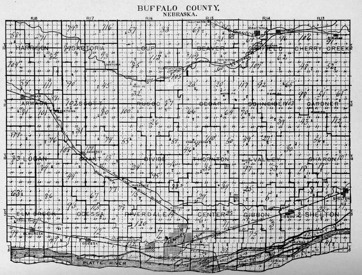
Page 710--To continue organization in Buffalo County.MAP OF BUFFALO COUNTY
Courtesy of H. A. Webbert, KearneyMap showing townships, ranges, names of townships, names of towns, .location of rivers, location of railroads, number, and location of .school districts in Buffalo County.
Issued from the office of County Superintendent J. S. Elliott for the school year 1914-1915.NEW CHANGES OF BOUNDARY NOT SHOWN ON MAP
SW¼ 34-11-18 from District No. 101 to 76. E½ of NW¼, W½ of NE¼ and NE¼ of NE¼ 21-11-14 from District 39 to 92. All of District No. 37 attached to District No. 101. E½ of NW¼ and NW¼ of NW¼ 21-11-15 from District No. 66 to 23. SW¼ 15-12-13 from District No. 91 to 106.
Map.
Click your browser's BACK button to return to this page.
13CHAPTER IV
BOUNDARIES OF BUFFALO COUNTY, ACT OF THE TERRITORIAL LEGISLATURE--NEBRASKA CENTRE THE SEAT OF JUSTICE (COUNTY SEAT)--ORIGINAL SURVEY OF THE COUNTY--NEBRASKA CENTRE ITS EXACT LOCATION--CENTRALIA AND NEBRASKA CENTRE PRECINCTS--TERRITORIAL ELECTION HELD IN 1859--POLL-BOOKS AND ELECTION RETURNS--THE EARLY SETTLEMENT IN THE PLATTE VALLEY--DOBYTOWN AND THE FAMOUS TOM KEELER RANCH--DAVID ANDERSON SPENDS THREE DAYS AT THE BOYD RANCH--TELLS OF AN ELECTION HELD THERE IN FALL OF 1859--WITNESSES TESTIFY AT CONGRESSIONAL INVESTIGATION AS TO LOCATION OF NEBRASKA CENTRE--LETTER FROM JOSEPH OWEN.
BOUNDARIES OF BUFFALO COUNTY
The County of Buffalo, one of the first eight counties named and boundaries established, was named and its boundaries first defined at the second session of the Territorial Legislature of Nebraska which convened at Omaha, Tuesday, December 18, 1855, at 10 o'clock in the forenoon. C Hon. Mark W. Izzard was territorial governor, Benjamine R. Folsom was president of the council and Erastus G. McNeely, chief clerk. The speaker of the House was William Larimer, Jr., and Joseph W. Paddock, chief clerk.
The act of the Territorial Legislature providing for the organization of Buffalo County follows:AN ACT To Organize Buffalo County.
Section 1. Be it enacted by the Council and House of Representatives of the Territory of Nebraska, That all that portion of Territory included in the following limits, is hereby declared organized into a county to be called Buffalo, commencing at a point in the centre of the Platte River, ten miles east from the mouth of Wood River, running thence westward up the southern channel of the Platte, to the mouth of Buffalo Creek, thence north thirty miles--thence east to a point directly north of the place of beginning, thence south to the place of beginning. The seat of justice is hereby located at Nebraska Centre.
Sec. 2. This act to take effect from and after its passage. Approved March 14, 1855.
In a general way it can be said the east line of the county thus established began at a point approximately south of the present City of Grand Island, and the western line of the county was near the present Village of Overton in Dawson County. Later, 1858-1871, the boundaries were changed to conform to the present boundaries.
14HISTORY OF BUFFALO COUNTY ORIGINAL SURVEY OF BUFFALO COUNTY
On the establishment of Fort Kearney in 1848, the war department ordered a military reservation of ten miles square surrounding the fort to be surveyed and established. Accordingly the Fort Kearney military reservation was surveyed in 1848, (Morton history), this being the first survey of record in the county, and it appears that the lines thus established were recognized in all future surveys in both Buffalo and Kearney counties. In 1866 the second and third standard township lines in the county were surveyed and established by H. C. F. Hackbusch, the third standard being the present north line of the county and the second standard the line between townships eight (8) and nine (9). In 1866 range lines 13, 14, 15, 16, 17 and 18 were run by George F. McClure. In the same year, 1866, the township and section lines in ranges 13, 14, 15 and 16 were run by Edwin R. Farnsworth and H. C. F. Hackbusch and in 1868 the township and section lines in ranges 17 and 18 were run by W. J. Allason. This completed the original survey of the county.
It will be noted that in the act organizing the county Nebraska Centre is named as the "Seat of Justice," the county seat; a history of Nebraska Centre somewhat in detail and as near as can be determined its exact location is herewith given:NEBRASKA CENTRE
In the first published account of Buffalo County, Territory of Nebraska, mention is made of Nebraska Centre, and in the maps of Central Nebraska and Buffalo County of that date a rather indefinite location is given of Nebraska Centre, which is not to be wondered at, as there had been no official survey made of this portion of the territory, but few people (squatters) resided here and of necessity the hamlet named "Nebraska Centre" could have consisted of only a few log habitations.
It has been generally understood, and the editor of this history has so understood and written, that the place known as Nebraska Centre from 1855 to 1860 was from 1860 to 1873 known as Wood River Centre, and from 1873 to date (1916) as Shelton. But such seems not to have been the case. History seems to disclose that Nebraska Centre was located at that point known since about 1860 as "Boyd's Ranch," which, when the lands in the county were surveyed in 1868, can best be described as the southwest one-quarter, section No. 14, town No. 9, range No. 14, now Gibbon Township, Buffalo County. Possibly a description, somewhat in detail, of settlements in Buffalo County previous to 1868, when the lands were surveyed and thrown open to settlement, may be of interest to a student of a history of our county. It appears that all travel in the Platte River Valley over the Overland-California-Mormon trail through what is now Buffalo County was south of Wood River. Until the building of the Union Pacific Railroad through the county in 1867 all settlements in the county were south of Wood River and adjacent to the above mentioned trail, and in the eastern portion of the county.
Fort Kearney was established in 1848. It was located on a military reservation ten miles square lying on both sides of the Platte River. The northeast
15HISTORY OF BUFFALO COUNTY corner of the reservation was on section No. 26, town No. 9, range No. 14, and the northwest corner of the reservation was ,on section No. 29, town No. 9, range No. 15. The military regulations in force at Fort Kearney did not permit any civilian to live upon the reservation--the ten miles square; in fact, no civilian was permitted to so camp over night. Reference to a map will disclose that the north line of the Fort Kearney Military Reservation was south of the Boyd ranch and less than two miles distant, and hence it was that all travel over the Overland-California-Mormon trail up and down the Platte Valley passed through what might be termed the "door yard" of the Boyd ranch. West of the Boyd ranch Wood River bears towards the north and west, while the above mentioned trail bore towards the south and west. Also about a mile west of the Boyd ranch, and south of Wood River, begins a low bluff, extending westward between the trail and Wood River, which is doubtless the reason there were few, if any, settlers in the early days along Wood River west of the Boyd ranch, as such settlers would have been distant from and out of sight of the trail traveled by emigrants.
Going west the trail divided at the Boyd ranch, or Nebraska Centre, one trail continuing up the Platte Valley, passing through where is now the City of Kearney, the villages of Odessa and Elm Creek. The other trail was to Fort Kearney, some eleven miles distant, being eight miles west and six miles south of the Boyd ranch, and on the south bank of the Platte. Quite naturally there would have been a "ranch," a "center," at the crossing of the Platte opposite Fort Kearney, but as the crossing point was on the military reservation, there could be no "ranch," no "hamlet," at that point.
History seems to disclose that previous to 1860 Nebraska Centre was located at the point later known as Boyd ranch; that it was the county seat of Buffalo County dating from the year 1855, when the county was named and bounded; that all the travel over the trail, on the north side of the Platte River, passed this point; that there was here a ranch and store where grain and provisions could be purchased, a saloon, and a "townhouse," where elections were held.
It appears that beginning with the year 1860 Wood River Centre became a center of recognized importance in Buffalo County, and Nebraska Centre ceased to be known to have a name in Central Nebraska and along the Overland trail. In the year 1858 Joseph E. Johnson located at a point on Wood River named Wood River Centre. In April, 1860, he established a newspaper called the Huntsman's Echo. He established a store, a tintype gallery, a blacksmith shop, a wagon repair shop, and most important of all, in the same year, a postoffice named Wood River Centre, himself as postmaster.
About that time the Western Stage Company extended its stage line from Iowa points through Omaha, up the north valley of the Platte to Fort Kearney, making their first stage station out of Fort Kearney at Wood River Centre on the farm now owned by Joseph Owen, and the station in charge of August Meyer, now (1916) living in Shelton.
It appears that beginning with the year 1860 Nebraska Centre ceased to have a legal existence, its name but a memory, and its exact location not with certainty determined by those of us residing in Buffalo County in the year 1916.
In the year 1859 an election for territorial officers was held in Buffalo County,
16HISTORY OF BUFFALO COUNTY and to Albert Watkins, historian for the State Historical Society, we are indebted for the returns of said election, including the names of the voters as copied from the poll books. These returns are as follows:
"At an election held in the townhouse of Nebraska Centre, in the Precinct of Nebraska Centre, County of Buffalo, and Territory of Nebraska, on Tuesday, the 11th day of October, 1859, the following named persons received the number of votes annexed to their respective names for the following described offices:
"Experience Estabrook had thirty-eight votes for member of Congress.
"William C. Wyman had thirty-eight votes for territorial treasurer.
"Robert C. Jordan had thirty-eight votes for auditor.
"Alonzo D. Luce had thirty-eight votes for librarian.
"William C. Harvy had thirty-eight votes for commissioner of common schools,
"James G. Chapman had thirty-seven votes for district attorney for First Judicial District.
"Richard C. Barnard had thirty-eight votes for member of the Legislature.
"JOHN HAMILTON,
"MORRISON M. MILLER,
"CONSTAN B. REYNOLDS,"Judges of Election.
"ROBERT J. JOHNSON,
"SAMUEL HOOD,
"Clerks of Election.
"I do hereby certify that this is a true copy of the poll books for the Precinct of Nebraska Centre, in Buffalo County.
"GEORGE MILLER, "County Clerk for Buffalo County, Nebraska Territory."
NAMES OF VOTERS IN POLL BOOK 1. Smith Kinsey
2. P. S. Gibbs
3. Harvy Estere
4. J. J. Lester
5. James E. Boyd
6. Charles Wilson
7. John H. Young
8. George Miller
9. C. H.Swits
10. M. Tory
11. William Mixlow
12. John Hamilton
13. R. S. Johnson
14. Morrison McMillen
15. Samuel Hood
16. S. R. Brown
17. Anan Henry
18. Henry Wilson
19. John Hamphill20. James Tierney
21. Carby Gooderman
22. James Mername
23. Alexander Givyneny
24. John W. Britt
25. Peter Kinney
26. Milo Tourend
27. David Narcy
28. Jeremiah Cox
20. J. C. Dorman
30. John Lux
31. T. Brown
32. B. Norman
33. Gustavus Stout
34. W. L. Brinton
35. T. J. Dorlan
36. David Anderson
37. John Davis
38. B. F. Brown
17HISTORY OF BUFFALO COUNTY
"At an election held at the house of J. H. Johnson, in the Precinct of Centralia, and County of Buffalo, and Territory of Nebraska, on Tuesday, October 11, A. D. 1859, the following named persons received the number of votes annexed to their respective names for the following described offices:
"Experience Estabrook, sixteen votes for member of Congress.
"William W. Wyman, sixteen votes for territorial treasurer.
"Robert C. Jordan, sixteen votes for auditor.
"Alonzo D. Luce, sixteen votes for librarian.
"William E. Harvy, sixteen votes for commissioner of common schools.
"James G. Chapman, sixteen votes for district attorney for First Judicial District.
"Richard C. Barnard, sixteen votes for member of Legislature.
"JOEL W. JOHNSON,
"THOMAS PAGE,
"JOHN EAMES,
"Judges of Election.
"J.W.WILSON,
"JOHN THORP,
"Clerks of Election."
NAMES OF VOTERS ON POLL BOOK 1. Henry Peck
2. Thomas Page
3. John Eames
4. J. H. Johnson
s. J. B. Lewis
6. John Thorp
7. J. W. Wilson
8. Henry Sharp9. John B. McCallister
10. James McCallister
11. George Gurney
12. John Cramer
13. Andrew Berry
14. Oliver M. Anderson
15. Joseph Houff
16. Patrick Carroll
"I do hereby certify that this is a true copy of the poll books for the Precinct of Centralia, in Buffalo County.
"GEORGE MILLER, "County Clerk for Buffalo County, Nebraska Territory."
As bearing upon the question of the exact location of Nebraska Centre, we copy from "Collections, Volume 16," of the State Historical 'Society, page 193, as follows:"THE EARLY SETTLEMENT OF THE PLATTE VALLEY
"By David Anderson
"(Paper read before the annual meeting of the Nebraska State Historical Society, January 18, 1910)"In the fall of 1859, after spending an exciting and adventurous summer in the newborn City of Denver, and the Rocky Mountains, in company with some old Pennsylvania friends with whom I had crossed the plains from Leavenworth City over the Smoky Hill route in the early spring, our party started from Denver with a mule team bound for Omaha.
18HISTORY OF BUFFALO COUNTY
"We followed the Pike's Peak trail, south of the south fork of the Platte River, to Julesburgh, thence down the old California trail to Fort Kearney. Great herds of buffalo, deer, elk and antelope were constantly in view. The Cheyenne Indians, who roamed over the plains between Fort Kearney and Denver, were furiously engaged in attacking emigrant trains, burning ranches and murdering the occupants. We had several skirmishes with the red devils who followed our trail many days.
"Ten miles west of Dobytown was the famous Keeler ranch. Here we met the notorious Tom Keeler, the terror of the plains and especially of the Cheyenne Indians. With all his native rudeness and roughness, however, Mr. Keeler was one of the most hospitable and generous men that I ever met. His buildings were all of sod, and the dwelling house was tidy and inviting. Mr. Keeler was loyally and lovingly attached to his wife and children.
"One day during the war period a cavalcade of rebels who were fleeing from the draft in Missouri stopped at his wells to obtain water for themselves and animals. Their mules were decorated with flags of the Confederacy, and the men were lustily hurrahing for Jeff Davis. This exhibition aroused Tom Keeler's Union feelings so intensely that he stood before the well with a gun in each hand, demanding that the rebel bunting be removed before any Union Nebraska water should be drawn. His wife stood at the door, armed with a double-barreled shotgun. After very acrimonious discussion the demand was complied with and the boisterous fugitives congratulated Keeler and his wife upon their courage and loyalty.
"A few weeks after we passed this ranch Mr. Keeler's stables, containing forty head of horses, together with 200 tons of hay, were wantonly set on fire by the Cheyenne Indians and totally destroyed. In later years Mr. Keeler removed to Eastern Nebraska and settled on the Elkhorn River, near Elkhorn City. In 1878 he met his death in a shotgun duel with Daniel Parmalee, a prominent citizen of Omaha.
"Dobytown, two miles west of Fort Kearney, contained about three hundred people. The houses were built of adobe or sod, one story high. It was on the extreme western verge of civilization and was a great rendezvous for outlaws and gamblers, who practiced their nefarious arts on the unsophisticated pilgrims.
"At a point opposite the fort the Platte River was three miles wide, containing numerous small islands and many deep and treacherous channels; yet this was the only real safe fording place between Julesburgh and the Missouri River.
"On arrival at the Boyd ranch, eleven miles east of the fort, our team was so fatigued that we were compelled to rest for three days. Here James E. Boyd operated a small trading post and ranch, carrying on a large traffic with the officers and soldiers of the fort, making profitable contracts for supplying wood from the margin of the river and from islands which had been reserved by the Government for military purposes; also for hay that grew abundantly on the Platte bottoms. While we tarried here the territorial election was held for choosing a delegate to Congress. This was the only polling place between Grand Island and Fort Kearney, a distance of thirty miles. The democratic candidate was Experience Estabrook of Omaha, and the republican candidate was Samuel
19HISTORY OF BUFFALO COUNTY G. Daily. There were twenty-two votes cast at the Boyd ranch, eleven of them by officers and soldiers from the fort. Great interest was manifested in the contest. I speak with emphasis and pleasure of the strenuous and useful career of Mr. Boyd. He assisted in the construction of the Union Pacific roadbed, projected the first railway north from Omaha, established the first large pork packing plant at Omaha and erected the first large theater in the city.
"The Wood River plain, which we followed a distance of twenty miles, presented a magnificent view; but there were only half a dozen settlers in that long stretch. At Wood River Crossing 'Pap' Lamb, well known along the Platte Valley, was operating a ranch and stage station. About this time the Western Stage Company, which was operating lines in Iowa, Wisconsin and other border states, established a route between Omaha and Pike's Peak--the name by which the Denver region was generally known--and stations were established from ten to fifteen miles apart. Mr. Lambs' ranch was one of them, and he drove to the next station west."
In a footnote to Mr. Anderson's paper (in part here quoted), Albert Watkins, historian for the State Historical Society, writes as follows:
"John K. Lamb, writing from Fort Kearney, April 11, 1860, to the Omaha Republican of April 18, 1860, remarked that Kearney City 'is better known as Adobe Town.' And he observed that Doctor Henry was doing a large business there. (Dr. Charles A. Henry was the father of Mrs. James E. Boyd.) Testimony taken by Samuel G. Daily in his contest against Experience Estabrook for a seat in Congress tended to show that at the time of the election of October 11, 1850, there were at Kearney City not over eight houses, not over fifteen residents, and not one acre of cultivated land or a farmhouse in the neighborhood of Kearney City. It also showed that at Nebraska Centre, the place named as the county seat (of Buffalo County), there was but one dwelling house, one storehouse and one warehouse. (Statement of Representative Campbell of Pennsylvania on behalf of Daily. Congressional Globe, first session, Thirty-sixth Congress, part 3, page 2180.) The returns of the election show that 238 of the 202 votes of Buffalo County were cast at Kearney City. These were rejected because Kearney City, being situated south of the Platte River, was not within Buffalo County."
Albert Watkins, historian of the State Historical Society, writing in reference to the location of both "Centralia" and "Nebraska Centre" says:
"Relevant to the footnote on page 196, 'Collections of the Nebraska State Historical Society,' Volume XVI: Stephen H. Wattles, a witness for Daily, testified that 'There is no such town as Centralia, but [it] is the name given to a precinct. The election purports to have been held at the house of Mr. Johnson, on Wood River.'
"The witness testified also, of Nebraska Centre, that 'It has one dwelling house, one storehouse, one barn or stable and one warehouse.' He said that he was at Nebraska Centre about eighteen hours and saw only three persons there who appeared to be residents. He testified further that Nebraska Centre and Centralia 'are on the direct line of thoroughfare from the Missouri River to the mines.' At Centralia he saw only four, five or six houses. He saw none anywhere except on Wood River."
20HISTORY OF BUFFALO COUNTY
The question of the definite location of Nebraska Centre was referred to Joseph Owen of Shelton. In explanation let it be said Mr. Owen came to Buffalo County in 1863 and has since resided here. Mr. Owen has served as treasurer of School District No. 1 since its organization in 1870 to date (1916). He has also served as a member and as chairman, of the county board of supervisors. His wife, whose maiden name was Sarah Ann Oliver, is a sister of Ed Oliver. Ed Oliver, also mentioned, came to Buffalo County in 1860. He worked for Joseph E. Johnson at Wood River Centre in 1860-61. He has served as county treasurer in 1871-72 and as a member of the board of county commissioners.
Mr. Joseph Owen, under date of January 28, 1916, writes, in substance, as follows: "I have always known that the J. E. Boyd place, when I came here in 1863, was known as Nebraska Centre, and Mr. Ed Oliver, who worked for J. E. Johnson (at Wood River Centre), never heard of Centralia Precinct. My wife (maiden name, Sarah Ann Oliver) was acquainted with the Wilsons (Charles and Henry) and Boyd, as she worked for Mrs. Boyd when a girl. Henry Wilson lived on the Kelsey place (this the northeast one-quarter section No. 13, town No. 9, range No. 14, in Gibbon Township). His father was drowned in the Platte River and his body never recovered, before I came here. John Britt and George Burke bought out Henry Peck in 1863. This land is now a part of the Village of Shelton. All the other people named as voting at the Boyd place (Nebraska Centre) are entirely unknown to the Olivers, and we are at a loss to know where they all lived. They certainly did not live along Wood River.
"Mrs. Owen says she was acquainted with Henry Peck, Thomas Page, John Eames, J. E. Johnson, Henry Sharp, John B. and James McCallister, Joseph Houff and Patrick Carroll. They all lived at Wood River Centre."
The Boyd ranch has a definite location. It was the first land filed upon in Buffalo County by Joseph Boyd in 1868. There seems no question but what the Boyd ranch was at Nebraska Centre.