|
windows when the wind blew from the direction of the Whites'.
Before the church was finished, Julia received word that her daughter, Isabelle Daniels, had not survived the birth of her seventh daughter, Isabelle. Julia went to South Dakota, returning with the baby to raise as her own. Isabelle was the first baby baptized in the Estina Catholic Church.
The farm is now the home of Mr. and Mrs. Elmer Witte.
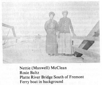 |
| | Nettie (Maxwell) McClean
Rosic Baltz
Platte River Bridge South of Fremont
Ferry boat in background |
THE LEE AND RANSFORD
FERRIES
Three non-steam ferries serviced the area between Saunders and Dodge Counties from July 1869 to September 1871. They were the Lee Ferry, south of Fremont; the Ransford Ferry, three miles west of Fremont; and the Selsar and Thomas Ferry at Valley Station.
The Lee Ferry, owned by J.M. Lee, one of the founders of the settlement of Wahoo, was the closest to Fremont and was situated on the mail route to Lincoln (later to become Highway 77) which meant it had the best location. Mr. Lee hired his young cousin, R.M. McClean, a newly-arrived immigrant from North Ireland to operate the ferry.
The ferry crossed only one channel of the river to an island. From this island a raised road and a series of bridges crossed to the south bank of the river. This spot or "landing" is on property now in the family of Larry and Mary Brown. Mary is the great-grand daughter of R.M. McClean, the man who operated the ferry.
However, very soon W.S. Ransford installed a steam engine on his ferry which was an instant success and caused great competition among the ferry lines. Then a broken cable on the ferry at the Valley Station allowed that ferry to travel downstream where it sank, after hitting a sand bar. It was never rebuilt or replaced. McClean continued to operate the Lee Ferry and Ransford was thriving "making a round trip every 30 minutes" according to the Fremont Newspaper July 30, 1869.
Ice appeared on the river during the last week of October and ferry operations were suspended. In the later part of February, the river was open enough for Ransford to move his boat down to Lee's Ferry landing, south of Fremont.
This move on the part of Ransford made it necessary for Lee to order a steam engine for his boat. April found both steam ferries doing a good business, crossing at the same site, as many as 50 teams a day.
Toll was 10¢ for a horse and rider, 25¢ for a team, wagon and driver, and 5¢ a head for extra passengers. Several families would go together with team and wagon as even 25¢ was hard to come by in those days.
A new steam ferry was now under construction. On June 6, 1870, the first steam ferry, actually designed and constructed for the use of steam power, was launched at the Fremont Shipyard. It was built by Judge M.H. Hinman and christened Queen of the Platte. The Queen, larger than either of the other two ferries in service, was 69 feet in length, 19 feet beam, 8 feet wide at the bow, and 15 feet wide at the stern. The boat, a stern wheeler, was powered by a 16 horsepower steam engine and drew only six inches of water.
The competition of the Queen apparently proved too keen for Lee and Ransford. Ransford moved his boat 17 miles upstream to North Bend. The citizens of North Bend, pleased to have a steam ferry of their own, subscribed a sum of $400 to help maintain the boat. John Lee met the problem of the new competitor in a different way; he became a captain of the Queen and Robert McClean was out of a job.
The new boat which crossed in three to five minutes and carried four teams proved superior to any previous ferry crossing at Fremont. However its noisy engines made some problems. A farmer named Knapp, with a team of mules that became frightened, attempted to back off the boat, but only succeeded in dumping about 100 pounds of butter and Knapp's wife into the river.
The Ransford Ferry returned to the Fremont area under rather unusual circumstances. Ransford's business did not seem to keep pace with his expenses so he mortgaged his boat to a number of North Bend citizens. These creditors, determined to have either their money or the boat, descended in mass upon the ferry landing. Ransford easily escaped by starting down river towards Fremont. The creditors, not easily discouraged, pursued Ransford down stream. Ransford reached Fremont before the posse and quickly sold the boat to J.H. Staats, a young man from New Jersey. The creditors, finding the boat, prepared to move it back to North Bend. Staats protested, but the posse got the boat back. Staats recovered it a few days later with the agreement that the ferry be operated at the old Ransford crossing, three miles west of Fremont. He continued to operate this ferry, mostly on a part-time basis, for some time. Later, in partnership with a Mr. Harmon, he built a toll bridge just north of where the Eagle Boy Scout Camp is now located. Staats was killed by lightning in 1877 while tending the toll bridge.
On Aug. 25, 1870, a bridge committee was selected and soundings were taken and bids let for a proposed bridge. The Smith Bridge Co. of Toledo, Ohio received the contract with a bid of $50,000. It was to be completed by June 1, 1871 and carried a five-year guarantee. It opened Sept. 21, 1871. A large section of it "washed out" the next spring when the ice jammed. Crossings had to be made by boat again, off and on, for the next few years.
However, with the coming of bridges a short picturesque period in the history of Platte River steam navigation came to an end.
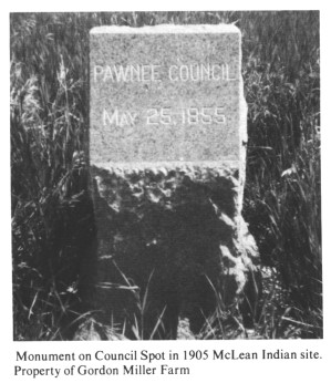 |
| Monument on Council Spot in 1905 McLean Indian site. Property of Gordon Miller Farm |
PAWNEE COUNCIL MONUMENT
A solitary stone marker on the Gordon Miller (the old Grandview Farm) sits on the bluffs south of Fremont. It designates the area where the first peace council between the Pawnee Indian nation and the Territory of Nebraska was held, May 25, 1855.
The marker was faithfully and proudly cared for by the McClean family for years. On May 25, 1905 this historical site was marked with the monument. General John M. Thayer, a central figure in peace councils with Indians 50 years earlier, came to give the speech. He and Professors Barrett and Sheldon of State Historical Society rode the early morning train from Lincoln to Cedar Bluffs and then to this farm, bringing the marker with them. Thayer picked the spot where the council had been held 50 years earlier with Chief Pita-le-sharu and Pawnee Indians. General Thayer told of his journey from Omaha to hold a parley with Pawnee tribe chiefs by direction of the governor. His wife had packed provisions for the party of four, but they had to leave their provisions in their wagon when they came to the point nearly opposite the McClean farm where they crossed the river. When they returned, the Indians had stolen everything. Gen. Thayer then informed the Indians they were expected to observe laws that required them to treat whites with friendliness. Chief Pita-le-sharu assured Gen. Thayer of the Indians' peaceful intentions. Henry T. Clarke of Omaha, president of the state association, performed the ceremony, set the marker in place, and gave the address. by Susan Miller
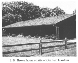 |
| L.K. Brown home on site of Graham Gardens. |
GRAHAM'S GARDENS
Many years ago a small lad whose name was F.A. Graham, lived in a tiny community of 14 families on the site of present-day Fremont, Nebraska. His father was instrumental in negotiating treaties with the nearby Pawnee Indians. This proved to be very fortunate, indeed, for when the tiny community was attacked by a warring Sioux tribe, it was the Pawnee Indians who came to their rescue. (It is generally felt that the white settlement was saved more because the Pawnee had bitter feelings for the Sioux.)
Close by lived the family of Winifred Mapes, a girl close in age to F.A. Graham. Eventually, Winifred and Graham were married and both became doctors.
The Doctors Graham felt much sentiment for Pahuk Hill and the surrounding acres because of their good feelings for the Pawnee Indians. They also greatly appreciated the beauty of the area. They decided to purchase the 25-acre area in the early 1900's and they called it Graham's Gardens.
The Grahams laid out detailed plans to develop the area. They set aside 15 acres to remain in their natural state. On the remaining 10 acres they planted bluegrass, baby oak trees and cedars. A rose hedge adorned the level spot on the point (the Indians' Sacred Hill, Pahuk Hill.) A lilac hedge was planted to line the edge of the bluff (the lilacs still bloom today). Some other flowers planted were blue bells, daisies, violets, Solomon's seal, wild roses, dogwood and pussy willow. In the early years the sumac prospered. Its glorious crimson abounds today.
West of the point is one of the most interesting features of the area. This is the old wagon trail (still plainly visible today) where wagons once crept down toward the Platte River on their way to the ferry boat landing.
The Grahams made elaborate plans for and built their home near the sacred point and on the edge of the bluff. An account in the Lincoln Star, dated August 10, 1924, tells of the difficulty they had digging a well. They had to dig 265 feet for good
page 103
| 