Part 1
The story of our county officially begins when it was formally organized as Saunders County on October 8, 1867, just months after Nebraska had become the 37th state of the Union. But the real story must be bound up with many important people and events of long ago.
PLATTE RIVER INFLUENCE
Nebraska's Platte, which forms the northern and eastern boundary of Saunders County, spans Nebraska from its western to eastern borders. It forms a broad corridor teeming with history, natural resources and wildlife, all of which greatly affected this country.
The Indians (Omaha and Otoe) called it the Nebraska, meaning "flat water". Platte is French for "flat", a true translation from the Indian. The French name stayed with the river.
Once the Platte divided the state much as the Mason and Dixon line divided the nation. All south of it was the Burlington's sphere of influence, and all north of it the U.P.'s. The South and North "Platters" vied for most everything, including the right to locate the capitol in their territory.
It is an odd stream, this Platte. Through most of its length it is a "braided" river - not forming a single channel but flowing as an interlaced network of small channels. It may have water to waste when no one wants it, and none at all in some places when every one wants it.
It changes course many times. For example, when the ferry boats crossed the river near Fremont, there were two channels, separated by an island called McClean Island and the first bridges to be built across the two channels were separated by the island. When the Burlington built its bridge, it dammed the south channel and diverted all the water to the north channel as it remains today.
At one time, the river flowed across the county from the northwest corner diagonally to the southeast corner at Ashland. Today this old river bed is called the Todd Valley. It is a beautiful flat farm land with occasional 'pockets' of swamp.
As early as 1813 and in 1830, Major Stephen H. Long of the Army Engineers followed the Platte westward. In 1830, the Sublette caravan took 10 wagons up the Platte, and the Great Platte River Road quickly replaced the Missouri River route to the Pacific North West. This route was shorter, easier, and its wide, smooth ascent to the Rockies was a great natural highway. It became the funnel thro' which America literally spilled over into the west. This great "road" curved along Saunders County on its complete northern boundary.
The valley was fertile and settlements increased. This dramatically changed the river that gave it its fertility, channel width, rate of flow, and even vegetation along the banks have been altered since 1865. The primary reason is agriculture, and irrigation, power generation and flood control. It is not the wild river it used to be; the new river seems a mere trickle compared with the old one. The early settlers depended on it for fish and wild life. The trees found on its many islands were used to build the early settlers' homes and supplied firewood for warmth.
The Platte has a charm which has nothing to do with politics, irrigation, power or any other economic use. Farmers who till the soil of its fertile valley feel it. Picnickers from town have discovered it. It is known to the fisherman angling for channel cat. The duck hunter gets a "snoot" full of it while he shivers behind his willow blind. Here nature has fashioned out of water and sand and silt and alluvial banks, a paradise of scenic loveliness. Unquestionably, Saunders County was greatly affected by the Platte River.
NAVY'S NEW U.S.S. PLATTE
Senator J.J. Exon was the main speaker at the commissioning of the Navy's new oiler, the U.S.S. Platte, April 16, 1983, at Norfolk, Va.
The new ship, which was christened in January, 1982, is the second in the Navy to be named after the Platte River. The first, also an oiler, earned 19 battle stars in three wars, between 1939 and 1970.
The first Platte served in World War II campaigns which included Midway, Guadalcanal, Okinawa, the Marianas and the Philippines. After the surrender of Japan, the Platte remained in Tokyo Bay as the station tanker for the occupation forces.
The Platte also was called into wartime action in Korea and Vietnam. When decommissioned in 1970, the oiler was the oldest active vessel in the Navy.
INDIANS OF SAUNDERS COUNTY
The county had been an area with heavy Indian population for centuries. All evidence suggests the lowest Indian population was just prior to the arrival of the white farmer settlers about 1830 - 1850. Research at the archaeological sites in the county reveal that man was in the county, probably as early as 12,000 years ago and most certainly lived here 6,000 to 9,000 years ago. The sites indicate they were farmer-hunter people with tools and pottery skills. Food supplies were the major controlling factors for population growths. Such things as drought, grasshopper plagues or perhaps long periods of severely cold years caused the early Indians to migrate and blend with other family groups. The vast open plains offered no barriers to the mixing and mingling of tribesmen.
Indian sites in the County:
- Bryant site near Yutan
- Estey site - seven miles south of Fremont
- McClean Site - immediately across the river from Fremont and continues along the bluff
- Leshara site - one of the principal Pawnee towns. This town was in existence at the time of Lewis and Clark Exp. and is mentioned in their reports as having been visited by one of their scouting parties. (This gives it a known history of almost 200 yrs.)
- Gibson Site near Swedeburg
- Ithaca Site (Indian Mound)
- Yutan Site
The Indians had little immunity to small pox and other contagious diseases of Europe. Through inter-marriage and contact with the fur traders the Indian population dwindled by the late 1700's. They had no medical skills to deal with these new diseases; as a result epidemics swept through the villages.
Their medical knowledge dealt with the use of herbs and the medicine man's cures with the help of their superstitious beliefs. Legend has it that a great chief's son was badly mauled by a wolf. The medicine man took the young teenager into one of the sacred caves, returning in a half-moon (2 weeks) with a well-healed lad. The magic of the medicine man and the spirit of the cave had healed the boy!
Pathologists from the University of Las Cruces, New Mexico, who investigated the legend, concluded that the molds in the cave, the cool damp air and condensed water dripping from the ceilings with molds, would have an effect of cooling the fever of the infection. Molds are the source of today's penicillins. With today's medical knowledge, the magic healing qualities of the Great Spirit in the caves of the lower Platte can be explained. taken from material by Alice Graham
OTOE INDIANS
When the first settlers stopped to settle in this county it was the Otoe and the Pawnee Indians they encountered.
The Otoes, once a part of the great Winnebago nation of the northern Great Lakes, were beset by overpowering enemies and driven south years ago. There they joined the Pawnees in the area near the mouth of the Platte River. A French trader mentioned them in 1797. He called them a "peaceful branch of the Sioux tribe under protection of the Pawnees, who were located on the south bank of the Platte River" (now northern Saunders County). In 1838, they abandoned their location - some going to what is now Otoe County and some remained.
They gave up all claims to their land here in March of 1854 when they ceded it to the U.S. government.
The Pawnees had lived here until they, too, reluctantly agreed to move in July of 1855. Under the leadership of their last great chief, Petalesharu, they gathered together their ponies and packed them with their goods and started for the valley of the Loup. However, many Pawnees became Army scouts under the leadership of Major Frank North during the years from 1858-67. Pioneers owed a great debt of gratitude to them.
CHIEF ITAN OF THE OTOES
Chief Itan, an Otoe Indian, lived on the hills of eastern Saunders County until 1837. He was reported in Army journals to have a dwelling 120 feet in diameter. Washington Irving accompanied such an expedition in 1832 and described the abode and Chief Itan. Believed to be the grandson of a French explorer, he was born before 1800. A tall, handsome and intelligent Indian, he was an able leader who consolidated the tribes of the wide Todd Valley by marrying Chiefs' daughters. The villages were a functional unit with a sufficient number of hunters, skilled women, and children to care for the needs of the people.
Managing his tribes well, Chief Itan had a vain streak - having fancy headdresses of many feathers, beaded clothing and deerskin garments as a part of his wardrobe. Lesser chiefs complained of his later arrival at council meetings due to his French vanity for fancy attire. This fondness for fancy dress sent him to the Dakota area to take two Mandan Indian women as wives. The Mandan were adept at designing and constructing soft deerskin garments. When Chief Itan introduced the disturbing element of his two Mandan wives, his other wives resented them as strangers from a different tribe.
Two young bucks decided to run away with the two Mandan wives of Itan. They escaped down-river toward the Missouri. When Itan overtook the fugitives, a fight insued. One young man was killed and Itan suffered a mortal wound, dying three or four days later. This spelled disaster for the tribe.
The next chosen tribal leaders disadvantageously traded the tribe's wares for whiskey. In a few years the Otoe tribe traveled up the Loup River to join with tribes there. Because they intermarried with the French trappers and traders they are known by history as the Half-breed Nation. With the Otoes out of the area the Pawnee moved eastward from the Republican River, using this area as their hunting grounds.
PAWNEE
By the time the Mormons were crossing Saunders County (1840), they encountered the Pawnee hunting parties. When the 49'ers traveled through on their way to California, Pawnee villages were found on the northern edge of the county. In 1854, General Thayer asked the Pawnee to move.
page 5
PAHUK HOLY HILL OF THE PAWNEES
Pahuk Holy Hill, 300 feet above the Platte River, and overlooking a vast sweep of the Platte Basin, was the holy place of the Pawnee tribe, the central sacred place in the Pawnee's thought and literature. There is a cycle of five such sacred places in Nebraska and northwest Kansas. The chief one is Pahuk. Being distinctly different from any other hill in all the Pawnee country, it stands in a bend of the Platte where the stream flows from the west in a sweep turning abruptly toward the southeast. The head of the hill juts out into the course of the river like a promontory or headland (the literal meaning of Pahuk). The north face of the bluff from the water's edge to the summit is heavily wooded with deciduous trees and evergreen cedars. The cedar is a sacred tree, so its presence adds mystery to the place. The Pawnees also speak of this hill as Nahurak Waruksti, which means sacred or mysterious animals.
Beneath the summit's surface, legend says, are grottoes and caves, rich in Indian lore and mystery. Captain Luther North, a leader of the famous Pawnee Scouts during the Sioux wars, described the entrance of the main cave as being below the water of the river.
True legend of the Pawnee mythology is lost; however, some stories remain. It is thought that the hill was inhabited by wild animals where the good men of the tribes went for instructions in supernatural powers of the medicine man. Here they found the "strength of the bear", and "cunning of the coyote". They "found the double gift of life on land and under water" from the beaver; they witnessed the "mailed armor of the turtle", and the wonderful melody of the meadowlark and the wood thrush, and on the pointing peak of Pahuk - "The soaring eagle taught them to fly as soon as they grew wings of wisdom". Pawnee lore repeatedly mentions "the Medicine Eagle" soaring high above Pahuk - the wonder bird dreamed of by the Pawnee.
Another particular account sets the spot as a vantage point where Indian scouting parties, commanding far-reaching views of the plains, observed westward pioneers. Just across the river to the north is the Lincoln Highway (U.S. #30), the trail to California and the Great Northwest. They also used it as a lookout for hostile Sioux.
Today no sign or marker indicates the location of this sacred spot. It is somewhere on one of the high points in northwest Pohocco or northeast Cedar Precincts. The southward turn in the river favors the Pohocco point. Also it is mentioned in the deed of the land which was once Graham's Gardens as to be there. Pohocco precinct is named for it. On the other hand, the inscriptions on the marker locating the proposed site of the Capitol (1858) Neapolis, says the Holy Hill was adjacent (to the east) of the spot, which would place it in the Cedar Precinct. In the 1920's, a committee from the State Historical Society brought a very old Skidi (Wolf tribe) Pawnee Chief named White Eagle (age 110 yrs.) from Oklahoma to pinpoint the exact location. He pointed to a spot in Cedar Precinct on land that had been in Edgar Cullen's family for three generations. Wherever it is, it remains unmarked and on private property. But, if one stands on either of these spots (not far apart) it is not hard to understand why they once inspired men, both red and white. by Dorothy Boettner
PETALESHARU
Mainly, the only Indians the early Saunders County homesteaders encountered were the Pawnee hunting parties and the Otoes who had moved up the Loup River (but occasionally many returned to their old home in the Todd Valley.) The Pawnees were a semi-sedentary farming people who lived in permanent villages but made periodic trips to hunt the buffalo.
One of these Pawnees was Chief Peter Leshara, Petalesharu, who led a small unit of people of mixed tribes. Over six feet tall, he was believed to be a descendant of a French trader. His large village was located on a high point of the river bluffs in the northern part of the county where Pohocco and Leshara Precincts are now found.
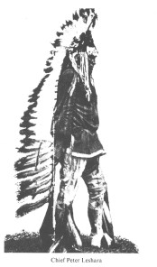 |
| Chief Peter Leshara |
The first settlers here tell the story of how he narrowly escaped death as a baby at the hands of a Sioux hunting party. His mother had unstrapped him from her back while hoeing corn some distance from the village. The Sioux then cut her off from escape when she ran to save her baby. But she gathered him up and scrambled over the bluff, swimming with him to safety down a swift channel of the Platte River to about the place where the town of Leshara is now located.
The pioneers knew him well and honored and respected him greatly. He was a deeply religious man, having the reputation of loving peace, especially if he had to fight for it. A professed Christian, his views on marriage were derived from the Old Testament.
In July of 1855 he was given the sad duty of leading his people away from this home, up the valley of the Loup, to a new temporary abode there. They had been driven to sign away their land because of the diminishing buffalo and the steady push of the white pioneer.
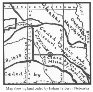 |
| Map showing land ceded by Indian Tribes in Nebraska |
SPANIARDS ON THE PLATTE
The early stories of the Spaniards in our country are wrapped partly in mystery and partly in dispute. Yet it is a known fact that the Spaniards at Sante Fe in 1720 attempted to conquer and settle the rich lands of Nebraska.
Due to the fact that pieces of armor from war suits have been found in northwest Saunders County in Bohemia precinct we can believe that the Spaniards must have engaged in a battle there. It is believed that when the fighting was over the Spaniards were dead and their horses taken by the Indians. Early Spanish records tell of an unlucky expedition into this region of the Platte River.
This area was part of a major Nebraska State Historical Society study in 1949, when archaeological crews unearthed numerous artifacts. It was part of an old village uncovered at nearby Linwood where among the items found are bits of Spanish bridles and a piece of a musket bearing the image of the Spanish eagle. It was a big village with at least 250 home sites.
TRADERS AND TRAPPERS IN THE COUNTY
The best accounts of early Indian life were recorded by the French expeditions. In 1700 organized French expeditions were sent to explore and claim the region in the name of the French King. They were accompanied by Jesuit priests to convert the Indians to Christianity. Worship services were held in this area in 1714. Fur traders were the next visitors as they followed the Platte River west. During the 1700's, while the English colonies were spreading on the eastern coast, the French developed commercial contacts with the Indians, remaining in trading posts or fortresses. The traders took Indian wives and lived peacefully among the different tribes.
Flat-bottomed boats loaded with furs passed along the edge of Saunders County on the Platte River. Stories of thievery, skull-duggery, escapes, fighting high water, or encounters with low water were a part of the tales of the fur traders. In 1795 Lewis and Clark listed a fur trapper or trader's station in southeast Saunders County. Reed and Curzatte lived there (Reed supposedly had deserted the Lewis and Clark Expedition north of Council Bluffs to return to the Otoe tribe near the mouth of Salt Creek). The trading post was located on a knoll on Clear Creek, three miles above the mouth of Salt Creek. It was burned several times by Indians after they had traded their furs. In the commotion they would steal back their furs.
In June, 1739, the Mallet Brothers crossed what is now Saunders Co. in their important visit to the Platte River country. They furnished much of the early knowledge of the region.
TRAILS THROUGH COUNTY
It has been said that Nebraska was a highway before it became a state. The Great River Road westward followed the Platte valley. The Oregon Trail crossing the state, called by the Indians, "Great Medicine Road of the Whites", was the most important and longest wagon trail in history. Alternate trails and highways from this and other trails crossed Saunders Co. from 1813.
There was a road from Nebraska City up the southern bank of the Platte which cut across the county. The "Ox-Bow" stage coach route cut across the southwestern corner of the county through Chapman Precinct.
The old California Trail from Nebraska City and Plattsmouth joined at Saline Ford and then proceeded up the "Branch" as Wahoo Creek was sometimes called. As the trails became more heavily traveled, they varied from their original courses for many miles because of the pressing need of the wagon trains for fresh water, firewood, and grazing land. Thus Saunders County was directly touched by these trails.
OX-BOW TRAIL
Many early pioneers crossed Saunders County along the Ox-Bow Trail. It was the wagon road for emigrants and freighters from about 1840 to 1867 before the railroads crossed the continent. It was first used by pioneers bound for Oregon and then by the Mormons and the forty-niners.
page 6
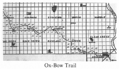 |
| Ox-Bow Trail |
This trail was a changeable route because weather or Indian raids or demands of military posts could cause alterations. The prairie was an uncharted and unmarked sea of grass so the earliest travelers followed the old Indian trails or simply "headed West." The Indians usually took to high ground to avoid swamps or other hostile Indians.
The Ox-Bow Trail has been known by many names. When the Mormons by-passed Florence because of cholera, it was called the Mormon Road. The 49er's called it the California Road. It was called the Freighter Road as the overland freight business grew. It was called the Military Road when the Territorial government used it to move Army supplies. When the freighting firms shortened the route by cutting straight west from Nebraska City the trail became known as the Old Freighters Road.
The name Ox-Bow came from the shape of the route which bent northward and followed the curve of the Platte like the wooden yokes worn by the laboring oxen that treaded its rutted course.
TEXAS CATTLE TRAIL
Cattle from Texas were trailed to Schuyler, Ne. from 1870 to 1872. The trail went through what is now Valparaiso. It followed Oak Creek north, crossing the County line into Butler County about straight west of Weston. It then angled into Schuyler, the Landing Point. Forty to fifty thousand Longhorn cattle were moved there in 1870. Many more cattle came in 1871 and some in 1872. By then, settlers to the south blocked the trail to Schuyler. The railroad then moved the loading station to Kearney, and in 1875 to Ogallala where cattle were driven through 1885. by Frank Tesar
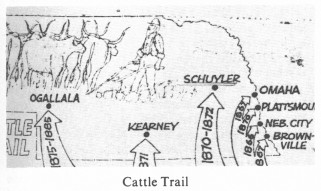 |
| Cattle Trail |
FERRY BOATS
The earliest ferry across the Platte River is reported to have been one operated by the Pawnee Indians in 1853. This was a floating barge which would hold a wagon and team. The Indians would make charges to the immigrants to cross the river.
Three non-steam ferries crossed the Platte River and serviced the areas between Saunders and Dodge County from July of 1869 to Sept. of 1871. On June 6, 1870, the first steam ferry, Queen of the Platte, entered the business. The ferry crossing at Fremont (Lee Line) was the shortest route to Lincoln. This fact was used by Jason Stephensen in an advertisement for his stage line:
Passengers and Mail
Shortest Route to Lincoln
New Coaches ...
Safe sure crossing at Fremont by steam ferry.
The only ford crossing the Platte River was the Saline Ford, where the present town of Ashland is located. This was the only limestone ledge base in the river in the whole trail system to the Rocky Mts. in southeast Nebraska Territory. Military shipments and troop movements were routed across Saline Ford as were most all settlers and wagon trade. There were times when people did manage to ford the river from northern Saunders Co. but not without great difficulty. The early Nebraska settlers found this only too true, as illustrated by this account of a homesteader, William Weber, who tried to ford the Platte:
"There was no bridge across the Platte River, and in order to cross you had to ford it ... I got into quicksand, and there I was. Unhitching the team from the wagon I sank into the quicksand myself some few inches, although not as deeply as the horses; anyway I had some fear lest I should not be able to get myself out. I managed to unhitch the horses. They were stuck with the wagon. After I unhitched them they had only themselves to get out which they did with some difficulty. The wagon couldn't be gotten out by my efforts alone so it stayed there. Afterwards a neighbor pulled me out."
Weber's experiences pointed to a need for a way to cross the river. The people turned to ferrying until bridges started to be built in the 1870's.
THE SURVEYORS
The first Nebraska surveyor was Rev. Isaac McCoy, a Baptist missionary, who surveyed a line across the southeast corner of the state from the Little Nemaha River to the Great Nemaha River in what is now Richardson County. (1837) The land between this line and Missouri River was called the Half Breed Strip. It was to be the home of those who were part white and part Indian. In later years there were many disputes over the location of this first Nebraska survey.
Surveyors were needed as soon as Nebraska became a territory to divide the land into blocks marked with permanent corners, so that each settler might know just where his land lay and the whole county might be made easy to map and easy to describe. The regular permanent survey of Nebraska into square blocks of land for people's homes began in Nov. 1854. First, a base line was measured west from Missouri River 108 miles, with each corner post marking each mile. This line was ordered to be exactly on the dividing line between Kansas and Nebraska - the 40th degree of latitude north from the equator.
The first surveyor did not do well because his line was crooked. A new survey by Charles A. Manners, aided by Capt. Thos. J. Lee, US Army, was made and a tall iron monument was erected May 8, 1855 on the spot where the 40th degree falls on the west back of the Missouri River. This is the starting point of all Nebraska surveys.
Beginning thus in the southeast corner of the state, they pushed on westward until finished, 56 years later, in 1910. The last survey was completed in Sheridan County.
EARLY LANDMARK
Lonely Elm - a landmark for early travelers through Saunders County. A lonely elm tree stood alone on Cottonwood Creek three miles north and west of Wahoo. Both the Indians and early settlers used the tree to help them with their directions.
FIRST MISSIONARY TO SAUNDERS COUNTY
Rev. Moses Merrill rode on horseback to the Otoe Indian village on the south bank of the Platte, near Ashland, in the spring of 1834. He and his wife, Eliza Wilcox, had been sent in 1833 by the Baptist Missionary Union to minister to the Otoe Indians. They drove an ox team from Missouri to Bellevue, where they stayed the first winter learning the Otoe language.
When Rev. Merrill reached the Indian villages he was received by Chief Itan, the great chief of the Otoes. Through the years of his ministry, he had a continual dispute with the Indians to teach them temperance. He translated portions of the Bible and several hymns into Otoe. His book of hymns, Wdtwhtl Wdwdklha Eva Wdhonetl, was the first Nebraska book ever made. In spite of all Mr. Merrill could do, the Otoe men cared more for whisky and less for good things every year. After Chief Itan's death, the young men became impudent and pretended to be Sioux in order to frighten the missionary family.
Feb. 6, 1840, Rev. Merrill became the victim of consumption due to exposure and overwork. He was buried on the east bank of the Missouri River opposite Bellevue. The Otoes called him "The-One-Who-Always-Speaks-The-Truth."1
1History & Stories of Nebraska, A.E. Sheldon, The University Publishing Co., Chicago, Ill. 1913, P. 70-75
BRIDGES ACROSS THE PLATTE(BETWEEN SAUNDERS AND DODGE CO.)
First bridge was completed Sept. 21, 1871, and was wrecked by ice the winter of 1872. This bridge was about 1/2 mile upstream, west of present-day bridge. It was known as the old Anderson bridge.
A toll bridge was built by J.H. (Jack) Staats and a Mr. Harmon just north of the Eagle Boy Scout Camp in 1873. It was swept away by waters in 1878. It was called the Harmon Bridge.
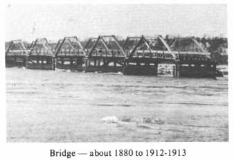 |
| Bridge - about 1880 to 1912-1913 |
A bridge committee built another bridge (piling of which can still be seen) a few yards east of present bridge. This one lasted until 1912-13.
The next "new" bridge was started in 1912 and finished in 1914, and lasted until torn down in 1955 (cost $85,000). During W.W. II there were traffic lights installed, making it one-way traffic on the bridge. In 1955, some of the spans were floated to Valley, where it was used to construct a new bridge there. The present-day bridge - the Motter Memorial bridge, was opened Oct. 29, 1955.
|