UNDERSTANDING LAND DESCRIPTIONS
Most people are confused by legal land descriptions until they've worked with them for a while, so don't feel alone. You will need to know a few basic facts before you can take a land description and locate it on a map. Like any measurement, you have to define where your beginning points will be. For Nebraska, all land descriptions are based on two lines: the baseline which goes east/west and the meridian that goes north/south.
Baselines are the beginning point for measuring Townships, and you will see designations of north or south as part of the description (don't confuse them with township names that may exist in a county). Nebraska uses the 44th parallel line for it's baseline, which forms the boundary line between Kansas and Nebraska. In Nebraska all Townships are north of the baseline; if you were in Kansas your Townships would be shown as south of the baseline. Each Township is a tier of land, six miles wide, that goes along the baseline. York County has four tiers of Townships: 9 North, 10 North, 11 North, and 12 North (look at the map below, where the tier of Township 9 North has been identified). Each land description, unless it is within a village/town, will include one of those four Township designations.
The 6th Principal Meridian is the beginning point for measuring Ranges in Nebraska, and it happens to go along York's western border. In York County all the Range descriptions will be West of the Meridian. In Seward County the ranges would all be East of the meridian. Each Range is a band of land six miles wide that runs parallel to the Meridian. All land descriptions in York County, unless it is witin a villiage/town, will include one of these four Range designations: 1 West, 2 West, 3 West, or 4 West. (look at the map below, where Range 1 West has been identified).
Each township/range is six miles square. By knowing the two coordinates, you can plot the location on a map. Below is how the Townships and Ranges are defined in York County. If you had a legal description that include Township 9 North, Range 1 West, it would be in the extreme southeastern corner of the county.
York County, Nebraska
T=Township R=Range
T 12 North R 4 West |
T 12 North R 3 West |
T 12 North R 2 West |
T 12 North R 1 West |
T 11 North R 4 West |
T 11 North R 3 West |
T 11 North R 2 West |
T 11 North R 1 West |
T 10 North R 4 West |
T 10 North R 3 West |
T 10 North R 2 West |
T 10 North R 1 West |
T 9 North R 4 West |
T 9 North R 3 West |
T 9 North R 2 West |
T 9 North R 1 West |
The key to reading a land description is to begin with the end and read it forward. Sometimes you will see abbreviated descriptions, which may make it a bit more difficult. Here are three examples of land descriptions you might see (all for the same land):
- A complete description might read: The west 1/2 of the northwest quarter, of Section 29, in Township 11 north of the baseline, and Range 3 west of the 6th Principal Meridian.
- A modified description may use abbreviations, fractions and little or no text : W1/2, NW1/4, S29, T11N, R3W
- A minimal desciption is just that, and generally only seen in local documents or situations (it's assumed you will know the missing parts): W2, NW4, 29-11-3.
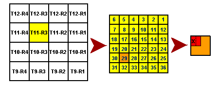
Let's take that example and break down how to read it. Remember, we want to start and the end and read backwards. You can follow the progression on the maps below.
- The last segment of the land description shows the Township and Range designations. In this example it shows Township 11 North, Range 3 West (the yellow area of the map below). We've now narrowed it down to a six square mile area (each Township/Range coordinate is six miles square.)
- Still reading backwards you see the next segment tells us they are in Section 29. Each Township/Range has 36 sections, or 36 square miles. We've now narrowed our search down to a single square mile (the orange section of the map below).
- Still reading backwards, we can see what portion of Section 29 (the square mile) they were in. In this example, are in the northwest quarter of the section (the red section of the map below).
- The last segment of the description tells us they had the west half of that quarter-section — the area with the "x" in it on the map.

If you are having difficulting reading or understanding a land description in York County, please feel free to e-mail us. We will gladly help you.
You
may link to these records, but do not frame, copy, or reproduce them without
written permission.
Copyright © 1997-2001, York
County Historical Association, or the compiler. All rights reserved.